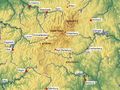
A series of hiking trails of the Winterberg High Tour (WHT), together making for a brisk walk of 44 kilometers. The Winterberg altimeter encompasses a total distance of 82 km and 2200 meters of elevation. This hiking trail starts at the Hotel Winterberg and follows the Rothaarsteig to the source of the Ruhr. Once on the WHT route, it heads towards Elkeringhausen, Züschen, and Mollseifen. Then it returns to the starting point along Neuastenberg and Lenneplätze.
Hai notato qualcosa su questo itinerario?Aggiungere un problema
Naviga nel percorso in...
![]() App RouteYou Aprire
App RouteYou Aprire
Vuoi smettere di vedere questo annuncio?
→ Upgrade ora
![]()
Attendi, la navigazione è in preparazione.
Ora puoi navigare. Buon divertimento in viaggio!
Elaborazione della richiesta non è riuscita. Si prega di riprovare.
Vuoi smettere di vedere questo annuncio?
→ Upgrade ora
![]()
Attendi, il tuo download è in preparazione.
Il tuo download è pronto. Buon divertimento in viaggio!
Elaborazione della richiesta non è riuscita. Si prega di riprovare.
Vuoi smettere di vedere questo annuncio?
→ Upgrade ora
![]()
Attendi, la tua stampa è in preparazione.
La tua stampa è pronta per il download. Buon divertimento in viaggio!
Elaborazione della richiesta non è riuscita. Si prega di riprovare.
<iframe src="https://plugin.routeyou.com/routeviewer/free/?language=it&params.route.id=566895&params.language=en" width="100%" height="600" frameborder="0" allowfullscreen></iframe>
<p><a class="routeYou_embed" href="https://app.routeyou.com/en-de/route/view/566895?utm_source=embed&utm_medium=article&utm_campaign=routeshare&navigation=external" title="Winterberg Heights Tour (WHT) - 45 km - RouteYou" target="_blank"><img src="https://image.routeyou.com/embed/route/960x670/566895-en@2x.png" style="width: 100%; height: auto;" alt="Winterberg Heights Tour (WHT) - 45 km"></a></p>
Altri commenti:
Questa funzionalità è disponibile esclusivamente per gli abbonati a RouteYou PREMIUM.
Prova 1 mese gratis e scopri la differenza! Non prendiamo alcun dettaglio di pagamento e la tua prova termina automaticamente dopo un mese.
© 2006-2026 RouteYou - www.routeyou.com