Road cycling route for cyclists who enjoy climbing with many "steep" ascents in Luxembourg. The ride is a variant of the Route des Pistes du Luxembourg.
You start in Stolzenburg, where you ride directly to the Putscheid Pass. The village of Bourscheid can be accessed from three sides. The last time, the route does not lead into the village, but nothing stops you from completing the course and then returning to the road.
Several serious trails follow, where the road always (wildly) drops!
After crossing Diekirch, you must face the ascent of Seitert and Rue de Herrenberg.
You end up in Bastendorf. From here, you descend to climb Longsdorf via Longsdorfer Straße. It's a climb that starts gently. The continuation from Longsdorf to Föhren becomes more challenging.
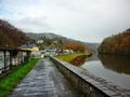
You descend into the valley of the Our. A little further towards Vianden, you take a very difficult ascent on a paved road in somewhat less good condition. Then you go back down to Vianden, past the castle. Enjoy the view!
In Vianden, you can walk down to the village center to tackle the entire slope of Mont Saint Nicolas, where you begin on the cobblestones by the banks of the Our.
Finally, the ascent of Mont Saint Nicolas from Vianden ends, followed by a nice descent along the Veinerstrooss.
Overall, you will cycle a bit more than 100 km with many elevation meters to overcome: almost 2400 m.
The main tracks:
- Stolzembourg Putscheid Pass: 2.2 km long with 272 meters of elevation. The average gradient of the climb is 12%. The maximum gradient is 17%.
- Bourscheider Küste from Bourschenter Millen: 3.51 km long with 260 meters of elevation. The average gradient of the ascent is 7.4%. The maximum gradient is 11%.
- Kohn Trail from Welscheid: 1.49 km long with 194 meters of elevation. The average gradient of the climb is 13%.
- Mont Saint Nicolas from Vianden: 2.8 km long with 286 meters of elevation. The average gradient of the ascent is 10%.
See something wrong on this route?Add an issue
Navigate route in...
![]() RouteYou app Open
RouteYou app Open
Don't want to see this ad anymore?
→ Upgrade now
![]()
Please wait, the navigation is being prepared.
You can now navigate. Have fun on the road!
Processing your request has failed. Please try again.
Don't want to see this ad anymore?
→ Upgrade now
![]()
Please wait, your download is being prepared.
Your download is ready. Have fun on the road!
Processing your request has failed. Please try again.
Don't want to see this ad anymore?
→ Upgrade now
![]()
Please wait, your print is being prepared.
Your print is ready to download. Have fun on the road!
Processing your request has failed. Please try again.
<iframe src="https://plugin.routeyou.com/routeviewer/free/?language=en&params.route.id=5279370" width="100%" height="600" frameborder="0" allowfullscreen></iframe>
<p><a class="routeYou_embed" href="https://app.routeyou.com/en-lu/route/view/5279370?utm_source=embed&utm_medium=article&utm_campaign=routeshare&navigation=external" title="WWu Slopes Route Luxembourg 100km - RouteYou" target="_blank"><img src="https://image.routeyou.com/embed/route/960x670/5279370-en@2x.png" style="width: 100%; height: auto;" alt="WWu Slopes Route Luxembourg 100km"></a></p>
Additional feedback:
This feature is only available to RouteYou PREMIUM subscribers.
Try 1 month for free and discover the difference! We don't take any payment details, and your trial ends automatically after one month.
© 2006-2026 RouteYou - www.routeyou.com