Azure
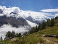
AzureQuesta escursione ti porta a due cime sopra Saas-Grund: Gibidum e Mällig. Da queste due piccole ma belle cime montuose si ha una magnifica vista sul Saastaal.
Questo percorso può essere iniziato da Saas-Almagell (come percorso) o da Saas-Fee (-8 km se si parte da Saas-Fee). Si noti che Saas-fee è una città senza auto, quindi è necessario parcheggiare in un parcheggio appena fuori dal villaggio (a pagamento).
Da Saas-Almagell proseguire in direzione di Saas-Fee, a Saas-Fee si attraversa il grande ponte sulla Feevispa in direzione dell'ufficio turistico. Da lì seguiamo una strada asfaltata verso "Grächen"/"Hannigalp". Prendiamo prima il sentiero attraverso la foresta (Steinwildpfad), tutte le deviazioni per Mällig vengono ignorate all'arrivo a Balmiböden. A questo punto saliremo alla prima vetta Gibidum. Da questa piccola vetta si può vedere la vetta del Mällig un po 'più lontano, quindi la navigazione è facile. Da entrambe le cime si ha una vista davvero fantastica sulla valle. Continuiamo la nostra discesa verso Hannig/Hannigalp, dove c'è una terrazza soleggiata. I quitters possono scendere con l'impianto di risalita, i veri escursionisti tornano attraverso la foresta a Saas-Fee. Da Saas-Fee prendiamo il sentiero forestale per tornare a Saas-Almagell.
Difficoltà:
T2 - Escursione in montagna
I sentieri sono chiaramente segnalati, ma alcuni tratti rocciosi sono facili.
Hai notato qualcosa su questo itinerario?Aggiungere un problema
Naviga nel percorso in...
![]() App RouteYou Aprire
App RouteYou Aprire
Vuoi smettere di vedere questo annuncio?
→ Upgrade ora
![]()
Attendi, la navigazione è in preparazione.
Ora puoi navigare. Buon divertimento in viaggio!
Elaborazione della richiesta non è riuscita. Si prega di riprovare.
Vuoi smettere di vedere questo annuncio?
→ Upgrade ora
![]()
Attendi, il tuo download è in preparazione.
Il tuo download è pronto. Buon divertimento in viaggio!
Elaborazione della richiesta non è riuscita. Si prega di riprovare.
Vuoi smettere di vedere questo annuncio?
→ Upgrade ora
![]()
Attendi, la tua stampa è in preparazione.
La tua stampa è pronta per il download. Buon divertimento in viaggio!
Elaborazione della richiesta non è riuscita. Si prega di riprovare.
<iframe src="https://plugin.routeyou.com/routeviewer/free/?language=it&params.route.id=4150736" width="100%" height="600" frameborder="0" allowfullscreen></iframe>
<p><a class="routeYou_embed" href="https://app.routeyou.com/it-ch/route/view/4150736?utm_source=embed&utm_medium=article&utm_campaign=routeshare&navigation=external" title="Gibidum (2764m) e Mällig (2700m) - RouteYou" target="_blank"><img src="https://image.routeyou.com/embed/route/960x670/4150736-it@2x.png" style="width: 100%; height: auto;" alt="Gibidum (2764m) e Mällig (2700m)"></a></p>
Altri commenti:
Questa funzionalità è disponibile esclusivamente per gli abbonati a RouteYou PREMIUM.
Prova 1 mese gratis e scopri la differenza! Non prendiamo alcun dettaglio di pagamento e la tua prova termina automaticamente dopo un mese.
© 2006-2026 RouteYou - www.routeyou.com