2293 views | Public | Dutch
Cycling in Southeast Brabant means occasionally getting off for a 'bakske' coffee or a beer in a brown village inn, a picnic in the forest or just a refreshing ice cream along the road. Along the paths that are part of the cycle route network you will find more than sixty cyclist-friendly stops. The cafés are specially focused on comfort for the cyclist. You can safely store your bike in a decent bike rack and there is always a repair box with tire adhesive and a bicycle pump. Always handy!
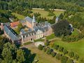
Meet at the spacious parking lot of the Norbertine Abbey (V) in Mol-Postel. Beforehand you can view your tour on the overview board. You leave for junction 77 and cycle away from the abbey, towards Balen. At junction 77, choose direction 76. You cycle straight for a few hundred meters and then turn left, away from the sometimes busy traffic road. Next to the dirt road there is a wide cycle path. First you go through a forest, then through an open agricultural landscape. You cycle over a rickety bridge and past border marker 196 (1). At junction 76 you cycle left into the Kapelweg, direction Bergeijk and junction 23. Along the way you pass 'bicycle café Kapellenhof'. At junction 23, continue straight ahead on Kapelweg towards 24. Don't worry about side roads and keep cycling straight through the open agricultural landscape. Then you dive into the forest with the Kapelweg. You cycle past 'tavern De Koperen Teut' and then arrive at junction 24. Here you choose right, direction 231. You cycle under the sign Open Air Theatre De Hunnebergen – anno 1930 (2) and continue your way on a narrow asphalt path through the forest. At the 'Postelhoeve', a holiday hotel with tailor-made senior holidays, turn right and continue cycling on a narrow asphalted cycle path, next to a mullezandweg. You drive through the forest and along the edge of the forest, with often impressive views. If there is no signage, let yourself be guided by the paved bike path. If you want to relax, you can use one of the numerous picnic areas that you will come across.
2. You now wave with the forest path and reach boundary marker 191 (3). On the Dutch side of the border, a beautiful picnic area. On the Belgian side, the municipality of Lommel welcomes you with remnants of a road sign and a broken rest bench. But that can't spoil the fun, you cycle carefree through the forest, on a blissfully undulating and winding asphalted bicycle path. Not surprisingly, you will encounter a lot of cyclists here. After the forest you drive along a beautiful piece of heath and then after a nod you come to the Herentals-Bocholt canal dug in 1843-1846 (and junction 231). On the right you see the beautiful S-shaped pedestrian bridge. Via that bridge you can go to the Sahara. You follow the channel to the left, towards 230. At that junction you continue to follow the canal towards 227 and cycle past the holiday park 'Vossemeren', although there is nothing to notice from the dike. You bolt under the next bridge and arrive at junction 227. Cyclists who want to combine this tour with the bike ride 'At the Trappists in Achel', drive straight ahead here and follow the description on that sheet until junction 25, where they switch back to this sheet. The two tours together are 88 km long.
3. This tour turns left here, away from the canal, towards 226. There you cycle straight on to 25. Along 'Nature reserve De Watering' - also called De Vloeiweiden - you meander past border post 187 (4) (behind a stream, half hidden in the green) and further past a dilapidated farm to junction 25. De Wateringen was originally an agricultural reclamation project. Water from the Bocholt-Herentals canal would transform the heathland into fertile meadows. The state built farms there in 1850 but the project failed. Eventually it became the property of the match manufacturer 'Union Allumettière' and finally, in 1976, of the municipality of Lommel. Cyclists who make the combination tour with the bike tour 'Bij de Trappisten in Achel', come here from the right, turn right and continue this tour.
4. You cycle towards junction 87 (this junction is inserted by the junction network) through an agricultural landscape. In a meadow you notice a drinking bowl, which is filled thanks to solar energy. The Achterste Aa turns into the Voorste Aa and takes you to the Bredasedijk. At junction 87 turn left and a little further you will come to a newly constructed roundabout (no sign with the number of the junction here for the time being), take the second exit. You cycle into 't Loo (Bergeijk) and drive along a moody triangular square. Via a clinker road you come to a cross road. Follow it to the left, direction Luyksgestel until you can turn right into the Weebosserweg. You now cycle towards Weebosch, along the edge of Bergeijk and then continue through an agricultural landscape. At junction 21, continue straight ahead on Weebosserweg, direction 20. This somewhat wider road has no cycle path, unusual for the Netherlands.
5. If you cycle into the built-up area of Weebosch, you do have a cycle path. You drive past some catering establishments and the village church and then arrive at junction 20. There you choose direction 19. Via the Witrijtseweg you are quickly there. Here you turn right, direction junction 11. You cycle on a narrow cycle path through the Johan Van Der Heidendreef. After a while it becomes unpaved, but you can continue to enjoy the paved bike path. After a piece of forest you cycle further along the edge of the forest and you have some beautiful views with here and there a farm. At a crossroads with picnic area you cycle straight until you come to a cross road with a separate cycle path. Follow it to the left, direction Eersel. At junction 11 you carefully cross the Postelseweg and reach junction 12 500 meters further. Here you choose direction 16. Now comes the icing on the cake. You cycle over a game grid up the Cartierheide. A beautiful heathland of 172 ha with many moist areas and fens. At the next game grid you drive out of the area again. Fortunately, you can still enjoy the forest for a while. You reach junction 16 and turn right, direction 18. The concrete turns into a dirt road and you continue cycling through the forest, on a separate cycle path. But you're already used to that. You come to a cross road and have to turn left until junction 18. Right in front of you you can see the legendary taverns 'Heidelicht' and 'De Kaasboerin' between the trees. But they are outside our route. So you have to turn left until you reach tavern 'Dennenlucht'. Here you are at junction 18 and at border post 197 (5). Cycle up the Grensweg, direction 22. After a few hundred meters you cycle on a tiled bike path through the forest. The tiles turn into asphalt and a little further you reach junction 22. On a mushroom you can read that you are still 4 km from the abbey. You follow direction junction 77, but you don't have to go that far, because at the abbey the tour is over. The concrete cycle path first winds between the fields, then you drive past the golf course of the 'Steenhoven Country Club'. You come back to civilization and end up a little further in the bend of the road to Eersel. You can already see the abbey. Don't forget to visit the abbey church. It's worth it. There is no shortage of possibilities to order a snack and a drink here either.
Navigate route in...
![]() RouteYou app Open
RouteYou app Open
Don't want to see this ad anymore?
→ Upgrade now
![]()
Please wait, the navigation is being prepared.
You can now navigate. Have fun on the road!
Processing your request has failed. Please try again.
Don't want to see this ad anymore?
→ Upgrade now
![]()
Please wait, your download is being prepared.
Your download is ready. Have fun on the road!
Processing your request has failed. Please try again.
Don't want to see this ad anymore?
→ Upgrade now
![]()
Please wait, your print is being prepared.
Your print is ready to download. Have fun on the road!
Processing your request has failed. Please try again.
Don't want to see this ad anymore?
→ Upgrade now
![]()
Please wait, your download is being prepared.
Your download is ready. Have fun on the road!
Processing your request has failed. Please try again.
<iframe src="https://plugin.routeyou.com/routeviewer/free/?language=en&params.route.id=5294841" width="100%" height="600" frameborder="0" allowfullscreen></iframe>
<a href="https://www.routeyou.com/en-be/route/view/5294841/recreational-cycle-route/east-of-postel?utm_source=embed&utm_medium=article&utm_campaign=routeshare" title="East of Postel - RouteYou" target="_blank"><img src="https://image.routeyou.com/embed/route/960x670/5294841-en@2x.png" width="960" height="670" alt="East of Postel"></a>
Additional feedback:
Try this feature for free with a RouteYou Plus trial subscription.
If you already have such an account, then log in now.
Try this feature for free with a RouteYou Premium trial subscription.
© 2006-2024 RouteYou - www.routeyou.com