Thanks to our partner Pasar vzw, you can get free access to this route AND familiarize yourself with RouteYou PLUS.
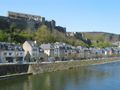
Discover all benefitsWhen you think of Bouillon, you might immediately think of the historic castle that dominates the town completely. But however imposing it may be, it is not the only asset of this small town.
Text and photo Mark Dedapper
Bouillon is nestled in one of the many meanders of the Semois. The natural beauty is overwhelming, with many viewpoints, beech and oak forests, adventurous paths, and idyllic spots along the Semois. In the town itself, various patrician houses from the 18th and 19th centuries have been carefully preserved. The small old district Quartier de Bretagne is also picturesque.
On the banks of the Semois, you pass by the beautifully located abbey of Cordemois, built in 1933 and inhabited by Cistercian sisters who are affiliated with the abbey of Orval. Finally, the lookout tower of Auclin offers a splendid view over the town and its surroundings.
The route
Start from parking Boulevard Heynen (V) – public transport: with low frequency. Leave the parking lot heading south. Turn left over the bridge and immediately left along the Semois. Follow GR signs. Shortly after the bend in the road, take a narrow alley on the left (Ruelle Berg-Op-Zoom). Where the alley starts to descend, take the path between the walls (GR) on the left. At the next fork, take the rocky path on the left. Where the path turns left again, follow the slope for a while. At the cross path, turn right and ascend. Once at the top, turn left. Immediately after that, you arrive at an intersection with a wide forest road. You see the lookout tower to your left. Cross the forest road and follow a slightly hidden path to the right. You are now following walk 7 (red rectangle) in reverse. Be careful, after 200 m at a post with walk 7, turn right steeply up. After a few meters, turn left. Follow this path, which is also an MTB route, for some time. At a fork, leave the MTB route that goes to the right, and follow the narrower path on the left. At the fork, follow the right branch – the left branch takes us to a magnificent viewpoint (1) over the Semois and the abbey of Cordemois. Note: there are some more difficult passages here. At viewpoint l’Épine (2), turn right on a steep descending path. Once down at a T-junction with a house, turn left (Moulin de l’Épine) (3) - a quiet asphalt road along the Semois and past the abbey of Cordemois (4) (also called abbey N.D. de Clairefontaine). Where the road bends to the left, at point Voie Wauthier (point A), take a narrow steep ascending path to the left (GR). //Straight ahead, you go directly to Point C//. After a strong ascent, you arrive at a wider path (point C). // Here you can shorten the walk by 2 km over the path on the right to point B. // Continue following the GR over the left branch. Ignore all side paths until you reach the lookout tower (5). Just before the tower, take the narrow descending path to the right (GR-Walk 7). You zigzag down towards the Semois. At point B, you come over concrete steps to the bridge of Cordemois, which you cross. Immediately after the bridge, turn right and just past a small tennis court, take the steps up to the left. You arrive at the entrance of the castle - left on Rue du Château. At the intersection, turn right on Rue du Nord – almost immediately, diagonally left into the picturesque Quartier de Bretagne. At the end, turn right on Rue du Brutz past the church and continue straight to the quay where the car is waiting.
See something wrong on this route?Add an issue
Navigate route in...
![]() RouteYou app Open
RouteYou app Open
![]()
Please wait, your print is being prepared.
Your print is ready to download. Have fun on the road!
Processing your request has failed. Please try again.
<iframe src="https://plugin.routeyou.com/routeviewer/free/?language=en&params.route.id=6844494" width="100%" height="600" frameborder="0" allowfullscreen></iframe>
<p><a class="routeYou_embed" href="https://app.routeyou.com/en-be/route/view/6844494?utm_source=embed&utm_medium=article&utm_campaign=routeshare&navigation=external" title="Bouillon, meeting point of history and nature - RouteYou" target="_blank"><img src="https://image.routeyou.com/embed/route/960x670/6844494-en@2x.png" style="width: 100%; height: auto;" alt="Bouillon, meeting point of history and nature"></a></p>
Additional feedback:
This feature is only available to RouteYou PREMIUM subscribers.
Try 1 month for free and discover the difference! We don't take any payment details, and your trial ends automatically after one month.
© 2006-2026 RouteYou - www.routeyou.com