Thanks to our partner haroldslegers, you can get free access to this route AND familiarize yourself with RouteYou PLUS.
Discover all benefits Azure
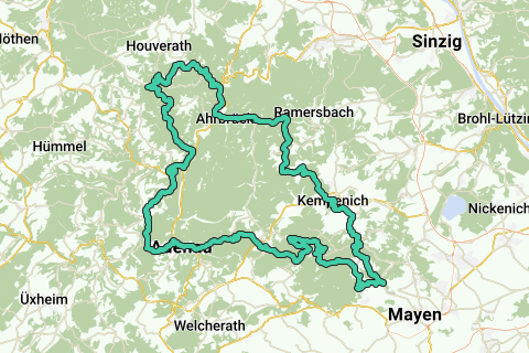
AzureThe Ahreifel is beautiful: climbs up to 6 km in length, many with hairpin bends, good and often quiet roads, mostly views on the crests (and no dense forest). The busy main road in the Ahr valley is bypassed in this valley by the well-paved exposed cycle path.
The route starts in Kreuzberg (some possibilities: hiking car park just before the bridge over the Ahr, or the car park on Bahnhofstraße). The route follows in a clockwise direction. First it goes a few kilometers on the bike path along the Ahr. Then it goes from the Ahr valley (at an altitude of 180 meters) to an altitude of about 600 meters. Then it goes over 2 climbs (which are steeper than on the rest of the route, up to 14%) to the beautiful Bürresheimer Castle. Then the path climbs from the village of Nitztal to Waldesch: this is a really nice climb over a narrow lonely road. Then it sets course for Langenfeld, then descends and, after 4 hairpin bends, turns left directly back up to the summit of the Raßberg: This area is known for its juniper bushes and the road is partially closed to car traffic. The route passes the highest point of the Eifel (the Hohe Acht) and leads down to Adenau. Adenau is a bustling village on the Nürburgring. Then it goes uphill again to Reifferscheid and over a quiet road hidden between the trees, in the direction of the Ahr valley. What remains are two beautiful climbs and equally beautiful descents (with many hairpin bends) around the valley of the Sahrbach.
See something wrong on this route?Add an issue
Navigate route in...
![]() RouteYou app Open
RouteYou app Open
![]()
Please wait, your print is being prepared.
Your print is ready to download. Have fun on the road!
Processing your request has failed. Please try again.
<iframe src="https://plugin.routeyou.com/routeviewer/free/?language=en&params.route.id=4419564" width="100%" height="600" frameborder="0" allowfullscreen></iframe>
<p><a class="routeYou_embed" href="https://app.routeyou.com/en-de/route/view/4419564?utm_source=embed&utm_medium=article&utm_campaign=routeshare&navigation=external" title="Hohe Eifel & Ahreifel - RouteYou" target="_blank"><img src="https://image.routeyou.com/embed/route/960x670/4419564-en@2x.png" style="width: 100%; height: auto;" alt="Hohe Eifel & Ahreifel"></a></p>
Additional feedback:
This feature is only available to RouteYou PREMIUM subscribers.
Try 1 month for free and discover the difference! We don't take any payment details, and your trial ends automatically after one month.
© 2006-2026 RouteYou - www.routeyou.com