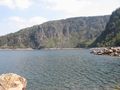
The Route des Crêtes is a road in the Vosges that connects all the heights of the Vosges massif in a north-south direction. The road lies between the Col du Bonhomme in the north and Cernay in the south.
The road was built in 1914 by the French army on the western side of a ridge in the Vosges that forms the border between Alsace and Lorraine. During the period 1871-1918, this was also the border between France and Germany. The road was used for the supply of French troops during World War I.
See something wrong on this route?Add an issue
Navigate route in...
![]() RouteYou app Open
RouteYou app Open
Don't want to see this ad anymore?
→ Upgrade now
![]()
Please wait, the navigation is being prepared.
You can now navigate. Have fun on the road!
Processing your request has failed. Please try again.
Don't want to see this ad anymore?
→ Upgrade now
![]()
Please wait, your download is being prepared.
Your download is ready. Have fun on the road!
Processing your request has failed. Please try again.
Don't want to see this ad anymore?
→ Upgrade now
![]()
Please wait, your print is being prepared.
Your print is ready to download. Have fun on the road!
Processing your request has failed. Please try again.
<iframe src="https://plugin.routeyou.com/routeviewer/free/?language=en&params.route.id=612611" width="100%" height="600" frameborder="0" allowfullscreen></iframe>
<p><a class="routeYou_embed" href="https://app.routeyou.com/en-fr/route/view/612611?utm_source=embed&utm_medium=article&utm_campaign=routeshare&navigation=external" title="Route des Crètes - RouteYou" target="_blank"><img src="https://image.routeyou.com/embed/route/960x670/612611-en@2x.png" style="width: 100%; height: auto;" alt="Route des Crètes"></a></p>
Additional feedback:
This feature is only available to RouteYou PREMIUM subscribers.
Try 1 month for free and discover the difference! We don't take any payment details, and your trial ends automatically after one month.
© 2006-2025 RouteYou - www.routeyou.com