Azure
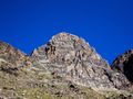
AzureIl Jegihorn è una "piccola" vetta sopra Saas-Grund (Valle di Saas, Vallese, Svizzera) con un'altezza di 3206 m. Dalla cima si ha una magnifica vista sul Weismiess (4017 m) e il suo ghiacciaio (Triftglacier) e le alte montagne 4000 + m sopra Saas-Fee.
!!! AVVERTIMENTO!!! T4 - Escursione alpina !!! AVVERTIMENTO!!!
Questa escursione è un'escursione contrassegnata bianca / blu / bianca, il che significa che questo è un sentiero alpino difficile solo per escursionisti di montagna esperti. L'inizio del sentiero è facile, appena si sale il Jegihorn, si passa dal sentiero di montagna bianco / rosso / bianco T2 al sentiero alpino. Da lì, il sentiero non è sempre chiaramente visibile, sono necessarie mani per superare le rocce, l'ultima parte alla vetta è ben segnalata, ma non facile da superare attraverso il mucchio di pietre. Devono essere sicuri, privi di altezze e avere esperienza in montagna.
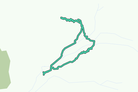
L'escursione inizia alla stazione sciistica di Kreuzboden, questo impianto di risalita è aperto in estate e può essere utilizzato da Saas-Grund. Da Kreuzboden si prosegue lungo la pista da sci verso Jegihorn / Hohsaas. Poco più avanti, un bivio a sinistra conduce alla salita del Jegihorn. Ci sono due percorsi qui, la sinistra è la via normale, la destra è la via ferrata. Prendiamo la via normale a sinistra. Il sentiero è buono all'inizio, ma diventa più difficile, con l'ultima parte prima della vetta che è un po 'più lavoro mano / piede. Il viaggio di ritorno è lo stesso, ma invece di tornare direttamente a Kreuzboden, visitiamo la Weismiesshütte prima di tornare a Kreuzboden.
Il percorso registrato sulla mappa non è incluso con la vetta, questo è intenzionalmente il caso. Si ferma appena sotto la vetta, dove il sentiero è relativamente fattibile per il normale escursionista di montagna, da questo punto il sentiero diventa difficile.
See something wrong on this route?Add an issue
Navigate route in...
![]() RouteYou app Open
RouteYou app Open
Don't want to see this ad anymore?
→ Upgrade now
![]()
Please wait, the navigation is being prepared.
You can now navigate. Have fun on the road!
Processing your request has failed. Please try again.
Don't want to see this ad anymore?
→ Upgrade now
![]()
Please wait, your download is being prepared.
Your download is ready. Have fun on the road!
Processing your request has failed. Please try again.
Don't want to see this ad anymore?
→ Upgrade now
![]()
Please wait, your print is being prepared.
Your print is ready to download. Have fun on the road!
Processing your request has failed. Please try again.
<iframe src="https://plugin.routeyou.com/routeviewer/free/?language=en&params.route.id=4143222&params.language=it" width="100%" height="600" frameborder="0" allowfullscreen></iframe>
<p><a class="routeYou_embed" href="https://app.routeyou.com/it-ch/route/view/4143222?utm_source=embed&utm_medium=article&utm_campaign=routeshare&navigation=external" title="Jegihorn (3206m) - RouteYou" target="_blank"><img src="https://image.routeyou.com/embed/route/960x670/4143222-it@2x.png" style="width: 100%; height: auto;" alt="Jegihorn (3206m)"></a></p>
Additional feedback:
This feature is only available to RouteYou PREMIUM subscribers.
Try 1 month for free and discover the difference! We don't take any payment details, and your trial ends automatically after one month.
© 2006-2025 RouteYou - www.routeyou.com