2773 views | Public
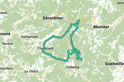
Begin in Cornimont en rij via de Route des Rosiers naar de D 43. Via Ventron beklim je de Col d'Oderen en daal je af naar Kruth. Ga bij de kerk linksaf tot het meer van Kruth-Wildenstein. Sla rechtsaf en begin de klim naar Le Markstein. Onderweg bij Le Treh heb je al een prachtig uitzicht: bij helder weer zijn zelfs de Mont Blanc en andere alpentoppen te zien! Bij Le Markstein volg je de Route des Cretes naar links: een glooiende route net onder de bergtoppen tot aan le Hohneck. Via een aantal haarspeldbochten kom je op het hoogste punt van deze route. Daal weer af en volg de Route des Cretes verder tot Col de la Schlucht. Ga daar naar links en daal af naar La Bresse en fiets weer terug naar Cornimont.
See something wrong on this route?Add an issue
Navigate route in...
![]() RouteYou app Open
RouteYou app Open
Don't want to see this ad anymore?
→ Upgrade now
![]()
Please wait, the navigation is being prepared.
You can now navigate. Have fun on the road!
Processing your request has failed. Please try again.
Don't want to see this ad anymore?
→ Upgrade now
![]()
Please wait, your download is being prepared.
Your download is ready. Have fun on the road!
Processing your request has failed. Please try again.
Don't want to see this ad anymore?
→ Upgrade now
![]()
Please wait, your print is being prepared.
Your print is ready to download. Have fun on the road!
Processing your request has failed. Please try again.
<iframe src="https://plugin.routeyou.com/routeviewer/free/?language=en&params.route.id=156804&params.language=nl" width="100%" height="600" frameborder="0" allowfullscreen></iframe>
<p><a class="routeYou_embed" href="https://app.routeyou.com/nl-fr/route/view/156804?utm_source=embed&utm_medium=article&utm_campaign=routeshare&navigation=external" title="Cornimont - Le Markstein - Le Hohneck - Col de la Schlucht - Cornimont. Totale stijging: ca. 1200 m. - RouteYou" target="_blank"><img src="https://image.routeyou.com/embed/route/960x670/156804-nl@2x.png" style="width: 100%; height: auto;" alt="Cornimont - Le Markstein - Le Hohneck - Col de la Schlucht - Cornimont. Totale stijging: ca. 1200 m."></a></p>
Additional feedback:
This feature is only available to RouteYou PREMIUM subscribers.
Try 1 month for free and discover the difference! We don't take any payment details, and your trial ends automatically after one month.
© 2006-2026 RouteYou - www.routeyou.com