
Link copied. Paste the link into Instagram to share the route.

Thanks to our partner Antwerpen Morgen you get free access to this route – and make your acquaintance with RouteYou PLUS.
Discover all benefits
Startpunkt
Ruige Heide, auf Höhe der Unterführung A12
Erreichbar mit:
Bus 671, 770, 771, 772, 778, 779, 780
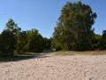
Landschaft Dieses Landschaftsbild steht in engem Zusammenhang mit den sandigen Kempen und hat einen viel ländlicheren Charakter als die andere Umgebung rund um Antwerpen. Das Heideland liegt isoliert von der Bebauung. Die A12 bildet eine harte Barriere, die dieses Gebiet von dem Rest der Stadt abschneidet. Diese Landschaft ist einzigartig in Antwerpen. Nirgendwo innerhalb der Stadt ist der Heide- und Boshabitat noch so intakt vorhanden. Die Antwerpener Zone schließt sich an das wertvolle grenzüberschreitende Natura2000-Gebiet „Zoom-Kalmthoutse Heide“ an, das sowohl ausgedehnte Vogelschutz- als auch Habitatschutzgebiete umfasst.
See something wrong on this route?Add an issue
Navigate route in...
 RouteYou app Open
Don't want to see this ad anymore?
→ Upgrade now

Please wait, the navigation is being prepared.
You can now navigate. Have fun on the road!
Processing your request has failed. Please try again.
Don't want to see this ad anymore?
→ Upgrade now
Please wait, your download is being prepared.
Your download is ready. Have fun on the road!
Processing your request has failed. Please try again.
Don't want to see this ad anymore?
→ Upgrade now
Please wait, your print is being prepared.
Your print is ready to download. Have fun on the road!
Processing your request has failed. Please try again.
Additional feedback:
This feature is only available to RouteYou PREMIUM subscribers.
Try 1 month for free and discover the difference! We don't take any payment details, and your trial ends automatically after one month.
© 2006-2026 RouteYou - www.routeyou.com


 Antwerpen Morgen




 Start
 Download
 Download


