After World War I, the Treaty of Versailles in 1919 stipulated that Germany had to cede a piece of its territory to Belgium. The region was incorporated as war booty into the district of Liège and is today known as the East Cantons, where German continues to be the language (with facilities for French speakers).
The East Cantons are rich in natural beauty: strongly hilly landscapes with numerous river valleys and forests. Heavy industry is hardly found there. The towns are large villages and the villages often hamlets. The southernmost part of the East Cantons, along the River Our, offers the richest panoramas.
TYPE OF PATHS
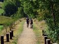
A mix. In the villages of Auel and Steffeshausen, you follow the normal, paved roads; in the forests, there are unpaved paths, and on the heights and in the Our valley, there are marked or roughly marked field paths. Rubber boots are not really necessary, but waterproof shoes are still recommended after rainy weather. The middle part of the route is punctuated with steep slopes: not feasible with wheelchairs or strollers. The hike is not recommended for completely untrained individuals.
SIGNAGE
The route is marked with horizontal yellow rectangles (mainly in the first half) and vertical blue rectangles (especially in the second half). Occasionally, you will also see the white-red color points of the Great Hiking Trail 56 (the trail of the East Cantons). Where necessary, the signs are mentioned in the description of the hike.
PARKING
You will need to look for a parking space - the options are not great - in the vicinity of the church of Auel, whose tower is crowned with a remarkable weather vane.
INFORMATION
Traffic Association Burg Reuland-Ouren, Burg-Reuland 106A, 4790 Burg-Reuland, Tel. and Fax 080 32 91 31, E-Mail: vv.reuland-ouren@skynet.be, Internet: eastbelgium.com/reuland-ouren.
See something wrong on this route?Add an issue
Navigate route in...
![]() RouteYou app Open
RouteYou app Open
Don't want to see this ad anymore?
→ Upgrade now
![]()
Please wait, the navigation is being prepared.
You can now navigate. Have fun on the road!
Processing your request has failed. Please try again.
Don't want to see this ad anymore?
→ Upgrade now
![]()
Please wait, your download is being prepared.
Your download is ready. Have fun on the road!
Processing your request has failed. Please try again.
Don't want to see this ad anymore?
→ Upgrade now
![]()
Please wait, your print is being prepared.
Your print is ready to download. Have fun on the road!
Processing your request has failed. Please try again.
<iframe src="https://plugin.routeyou.com/routeviewer/free/?language=en&params.route.id=4616" width="100%" height="600" frameborder="0" allowfullscreen></iframe>
<p><a class="routeYou_embed" href="https://app.routeyou.com/en-be/route/view/4616?utm_source=embed&utm_medium=article&utm_campaign=routeshare&navigation=external" title="Auel - RouteYou" target="_blank"><img src="https://image.routeyou.com/embed/route/960x670/4616-en@2x.png" style="width: 100%; height: auto;" alt="Auel"></a></p>
Additional feedback:
This feature is only available to RouteYou PREMIUM subscribers.
Try 1 month for free and discover the difference! We don't take any payment details, and your trial ends automatically after one month.
© 2006-2026 RouteYou - www.routeyou.com