Azure
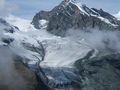
AzureAl bacino di Mattmark c'è un piccolo picco molto bello nelle vicinanze, da cui si ha una splendida vista sul ghiacciaio Allalin. Dal lago stesso hai solo un piccolo scorcio del ghiacciaio da catturare, quindi merita sicuramente una visita!
L'escursione inizia al lago, dove si segue il lato destro del lago e si prende il primo sentiero a destra, dove si segue una piccola strada per una piccola baita. Da lì parte un piccolo e in parte ripido sentiero fino alla cima dello Schwarsbergchopf. Gli alpinisti possono camminare su questo percorso fino al rifugio Brittannia, il sentiero è anche ben segnalato, ma richiede più attrezzatura.
Il ritorno avviene allo stesso modo.
See something wrong on this route?Add an issue
Navigate route in...
![]() RouteYou app Open
RouteYou app Open
Don't want to see this ad anymore?
→ Upgrade now
![]()
Please wait, the navigation is being prepared.
You can now navigate. Have fun on the road!
Processing your request has failed. Please try again.
Don't want to see this ad anymore?
→ Upgrade now
![]()
Please wait, your download is being prepared.
Your download is ready. Have fun on the road!
Processing your request has failed. Please try again.
Don't want to see this ad anymore?
→ Upgrade now
![]()
Please wait, your print is being prepared.
Your print is ready to download. Have fun on the road!
Processing your request has failed. Please try again.
<iframe src="https://plugin.routeyou.com/routeviewer/free/?language=en&params.route.id=2259721&params.language=it" width="100%" height="600" frameborder="0" allowfullscreen></iframe>
<p><a class="routeYou_embed" href="https://app.routeyou.com/it-ch/route/view/2259721?utm_source=embed&utm_medium=article&utm_campaign=routeshare&navigation=external" title="Allo Schwarzbergchopf (2871m) - RouteYou" target="_blank"><img src="https://image.routeyou.com/embed/route/960x670/2259721-it@2x.png" style="width: 100%; height: auto;" alt="Allo Schwarzbergchopf (2871m)"></a></p>
Additional feedback:
This feature is only available to RouteYou PREMIUM subscribers.
Try 1 month for free and discover the difference! We don't take any payment details, and your trial ends automatically after one month.
© 2006-2025 RouteYou - www.routeyou.com