Azure
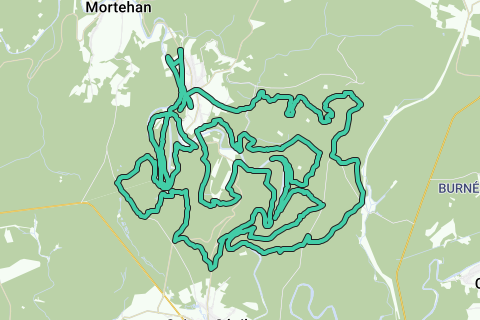
AzureLe Tombeau du Chevalier trail (58.76 km; D+ 2100m); southern version Herbeumont.
Based on http://www.festival-trail-semois.be/index.php's latest trail 'under construction' data, NGI topographic maps, own knowledge of the area and GPX records of the most important parts of the trail. The current trail eventually became not this one, but the north trail.
Following the Semois between Les Mauleûx and La Roche du Chat, I deviated from the path under construction and followed the forest path along the Semois to the south, after which the ascent begins north to Rue des Épioux along a forest road.
The flat distance is therefore 57km, the actual distance that takes into account the elevations to be covered is 58.76km; The altimeters to overcome are 2100m. See the first POI of this loop (Topographic Data The Knight's Tomb) for a detailed map and figures.
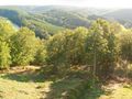
This trail is highly recommended for athletes who like to stay in the forest and who like an altitude difference of more than 2000m over more than 55km.
See something wrong on this route?Add an issue
Navigate route in...
![]() RouteYou app Open
RouteYou app Open
Don't want to see this ad anymore?
→ Upgrade now
![]()
Please wait, the navigation is being prepared.
You can now navigate. Have fun on the road!
Processing your request has failed. Please try again.
Don't want to see this ad anymore?
→ Upgrade now
![]()
Please wait, your download is being prepared.
Your download is ready. Have fun on the road!
Processing your request has failed. Please try again.
Don't want to see this ad anymore?
→ Upgrade now
![]()
Please wait, your print is being prepared.
Your print is ready to download. Have fun on the road!
Processing your request has failed. Please try again.
<iframe src="https://plugin.routeyou.com/routeviewer/free/?language=en&params.route.id=709108" width="100%" height="600" frameborder="0" allowfullscreen></iframe>
<p><a class="routeYou_embed" href="https://app.routeyou.com/en-be/route/view/709108?utm_source=embed&utm_medium=article&utm_campaign=routeshare&navigation=external" title="Trail Le Tombeau du Chevalier (58.8km), South version Herbeumont - RouteYou" target="_blank"><img src="https://image.routeyou.com/embed/route/960x670/709108-en@2x.png" style="width: 100%; height: auto;" alt="Trail Le Tombeau du Chevalier (58.8km), South version Herbeumont"></a></p>
Additional feedback:
This feature is only available to RouteYou PREMIUM subscribers.
Try 1 month for free and discover the difference! We don't take any payment details, and your trial ends automatically after one month.
© 2006-2025 RouteYou - www.routeyou.com