Link copied. Paste the link into Instagram to share the route.

La Ruta de los Castillos recorre una hermosa y histórica parte del Parque Nacional Utrechtse Heuvelrug.
El Parque Nacional es un área en su mayoría montañosa de aproximadamente 6000 ha (60 km²). Hasta la fecha, cubre la parte sureste de la Utrechtse Heuvelrug y está compuesta por bosques, páramos, dunas de arena y pastizales. En el lado sur se encuentran las riberas del Nederrijn. El límite norte está formado por la A12. Por el lado norte, la Utrechtse Heuvelrug se transforma en Het Gooi. La separación entre la Heuvelrug y Het Gooi es la Laagte van Pijnenburg.
A través de los bosques y las propiedades, la cordillera se había convertido en un entorno atractivo para los habitantes de las ciudades del oeste desde el siglo XVII. La accesibilidad aumentó en 1815 con el asfaltado del camino de De Bilt a Rhenen. A partir de ese momento, se observa un fuerte aumento en el número de propiedades; en el área del Parque Nacional hay alrededor de 80 lugares que se pueden reconocer como propiedades.
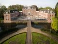
Particularmente a finales del siglo XVIII, muchos ricos holandeses se establecieron en esta parte de la Utrechtse Heuvelrug y crearon hermosas propiedades, donde generalmente pasaban unos meses al año. A menudo se diseñaban jardines y parques alrededor de los castillos, mansiones y propiedades, donde podemos ver un desarrollo de diferentes estilos. La mayoría de estas propiedades se encuentran a lo largo de la actual N225. Hoy en día, muchas propiedades son propiedad de empresas, que han establecido sus oficinas allí. Algunas han caído en decadencia e incluso han sido demolidas.
Desde principios del siglo XIX, esta parte de la Utrechtse Heuvelrug es conocida como ‘La Lustwarande de Sticht’.
See something wrong on this route?Add an issue
Navigate route in...
 RouteYou app Open
Don't want to see this ad anymore?
→ Upgrade now

Please wait, the navigation is being prepared.
You can now navigate. Have fun on the road!
Processing your request has failed. Please try again.
Don't want to see this ad anymore?
→ Upgrade now
Please wait, your download is being prepared.
Your download is ready. Have fun on the road!
Processing your request has failed. Please try again.
Don't want to see this ad anymore?
→ Upgrade now
Please wait, your print is being prepared.
Your print is ready to download. Have fun on the road!
Processing your request has failed. Please try again.
Additional feedback:
This feature is only available to RouteYou PREMIUM subscribers.
Try 1 month for free and discover the difference! We don't take any payment details, and your trial ends automatically after one month.
© 2006-2026 RouteYou - www.routeyou.com



 MX-5 Roadster Club NL






 Start
Start Download
 Download

