Questa leggera escursione montana di difficoltà medio-facile inizia a Galtür e conduce in una affascinante regione montuosa. Lungo il percorso attraverso il romantico Jamtal si aprono splendide viste sulle cime della Silvretta, in particolare sul ghiacciaio del Jamtal con le cime del Jamtal (3.156 e 3.178 metri) e sulla vetta dei Tre Confini (3.197 metri). L'obiettivo del tour è il rifugio Jamtalhütte a 2.165 metri di altitudine. Dopo una pausa si ritorna per lo stesso percorso.
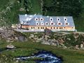
Dalla fermata dell'autobus presso la chiesa di Galtür (1.584 metri) si procede verso sud nel Jamtal, lungo il Jambach con una moderata salita in direzione valle. Seguire il "Sentiero per il rifugio Jamtal". La prima tappa intermedia è la Schnapfenalpe (1.735 metri), raggiungibile dopo circa un'ora di cammino. Qui pascolano mucche provenienti da Göfis nel Vorarlberg e dalla Valle dell'Inn superiore del Tirolo. Dall'altra parte si affaccia la Scheibenalpe. Ora il terreno cambia, i prati di montagna vengono sostituiti da un incavo roccioso nella valle. Dei ponti di legno aiutano a superare due torrenti, il sentiero si snoda verso il piede del ghiacciaio del Jamtal e verso il rifugio Jamtalhütte (2.165 metri). Qui vale la pena fare un giro dietro la casa per ammirare la vista sulla testata della valle con le cime del massiccio dell'Augstenberg e i vicini campi di ghiaccio. Gli alpinisti utilizzano il rifugio come base per escursioni ampie. Decine di cime possono essere scalate da qui.
See something wrong on this route?Add an issue
Navigate route in...
![]() RouteYou app Open
RouteYou app Open
Don't want to see this ad anymore?
→ Upgrade now
![]()
Please wait, the navigation is being prepared.
You can now navigate. Have fun on the road!
Processing your request has failed. Please try again.
Don't want to see this ad anymore?
→ Upgrade now
![]()
Please wait, your download is being prepared.
Your download is ready. Have fun on the road!
Processing your request has failed. Please try again.
Don't want to see this ad anymore?
→ Upgrade now
![]()
Please wait, your print is being prepared.
Your print is ready to download. Have fun on the road!
Processing your request has failed. Please try again.
<iframe src="https://plugin.routeyou.com/routeviewer/free/?language=en&params.route.id=15259288&params.language=it" width="100%" height="600" frameborder="0" allowfullscreen></iframe>
<p><a class="routeYou_embed" href="https://app.routeyou.com/it-at/route/view/15259288?utm_source=embed&utm_medium=article&utm_campaign=routeshare&navigation=external" title="Jamtalhütte - RouteYou" target="_blank"><img src="https://image.routeyou.com/embed/route/960x670/15259288-it@2x.png" style="width: 100%; height: auto;" alt="Jamtalhütte"></a></p>
Additional feedback:
This feature is only available to RouteYou PREMIUM subscribers.
Try 1 month for free and discover the difference! We don't take any payment details, and your trial ends automatically after one month.
© 2006-2026 RouteYou - www.routeyou.com