532 vues | Public | Italien • allemand • français • néerlandais
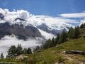
This hike takes you to two peaks above Saas-Grund: Gibidum and Mällig. From these two small but neat mountain summits you'll get an amazing view over the Saastaal.
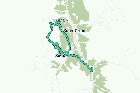
This route can be started from Saas-Almagell (as routed) or from Saas-Fee (-8km if you'll start from Saas-Fee). Be aware that Saas-fee is a car-free town, so you'll have to park just outside the village in a parking lot (payed).
From Saas-Almagell you'll navigate in the direction of Saas-Fee, once arrived at Saas-Fee cross the big bridge over the Feevispa in the direction of the tourist office. From there we follow an asphalt road in the direction of "Grächen"/"Hannigalp". We'll take the path through the forest (Steinwildpfad) first, all junctions to Mällig will be ignored upon arriving at Balmiböden. It's upon that point we'll be climbing towards the first peak Gibidum. From this little peak you'll see the Mällig peak a bit further so navigating is easy. From both peaks you'll get a really great view over the valley. We descent further in the direction of Hannig/Hannigalp where's a sunny terrace to enjoy. The quitters can take the ski lift down, the real hikers return to Saas-Fee through the woods. From Saas-Fee we'll take the forest route back to Saas-Almagell.
Difficulty:
T2 - Mountain hike
Paths are clearly marked, few rocky sections but easy.
Vous avez remarqué quelque chose sur cet itinéraire ?Ajouter rapport
Parcourir l'itinéraire dans...
![]() Application RouteYou Ouvrez
Application RouteYou Ouvrez
Vous ne voulez plus voir cette publicité ?
→ Actualiser maintenant
![]()
Veuillez patienter, la navigation est en cours de préparation.
Vous pouvez maintenant naviguer. Bonne route !
Le traitement de la demande a échoué. Veuillez réessayer.
Vous ne voulez plus voir cette publicité ?
→ Actualiser maintenant
![]()
Veuillez patienter, votre téléchargement est en cours de préparation.
Votre téléchargement est prêt. Bonne route !
Le traitement de la demande a échoué. Veuillez réessayer.
Vous ne voulez plus voir cette publicité ?
→ Actualiser maintenant
![]()
Veuillez patienter, votre impression est en cours de préparation.
Votre impression est prête à être téléchargée. Bonne route !
Le traitement de la demande a échoué. Veuillez réessayer.
<iframe src="https://plugin.routeyou.com/routeviewer/free/?language=fr&params.route.id=4150736&params.language=en" width="100%" height="600" frameborder="0" allowfullscreen></iframe>
<p><a class="routeYou_embed" href="https://app.routeyou.com/en-ch/route/view/4150736?utm_source=embed&utm_medium=article&utm_campaign=routeshare&navigation=external" title="Gibidum (2764m) and Mällig (2700m) - RouteYou" target="_blank"><img src="https://image.routeyou.com/embed/route/960x670/4150736-en@2x.png" style="width: 100%; height: auto;" alt="Gibidum (2764m) and Mällig (2700m)"></a></p>
Commentaires supplémentaires :
Cette fonctionnalité est exclusivement disponible pour les abonnés RouteYou PREMIUM.
Essayez 1 mois gratuit maintenant et découvrez la différence ! Nous n'exigeons aucune donnée de paiement et le service s'arrête automatiquement après votre période d'essai d'un mois.
© 2006-2025 RouteYou - www.routeyou.com