Thanks to our partner haroldslegers you get free access to this route – and make your acquaintance with RouteYou PLUS.
Discover all benefits Azure
AzureThe Kempisch Plateau (or Kempens Plateau) is a plateau that rises 30 to 50 meters above the surrounding landscape. It stretches from Bree in the north, to Gellik in the south. The edges on the east side of this plateau are steep with height differences of 30 to 50 meters. On the plateau it is mainly the Bosbeek that has carved out some relief (up to 20 meters height difference). In the northern part, the Itterbeek and the Eetsevelderbeek have carved out some relief in the plateau.
The route starts in Opitter clockwise and descends in a southerly direction. Sometimes you follow busier lanes with bike lanes along them, but no longer than a mile. Around Opoeteren there are some climbs waiting, of which the Jonkersweg is the steepest (up to 10%). The biggest height difference can be found near Dilsen. Unfortunately, since 2017 it is no longer allowed for cyclists to cycle from Dilsen via the N771 and the Driepaal road, due to a new traffic situation around the new access road to the industrial area of Dilsen (Heulentakstraat). As a result, the ascent of the Driepaal is no longer possible. A new cycle path has been built to bridge this part, which leads to the tourist cycle path Maaseik - As.
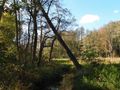
Then you cycle for miles on the asphalted cycle path that has been built over the route of the former railway line between As and Maaseik. Near As you leave the cycle path and cross the Bosbeek valley, with some short climbs on both sides of the valley. Especially the Caelenberg stands out here in terms of steepness. Fortunately, the headwaters of the Bosbeek are a nature reserve, so you can cross the forest stream valley here on often quiet roads (sometimes car-free roads).
Via the Dornerheide and the forest area between Opoeteren and Neerglabbeek, you cycle (sometimes on free-lying asphalted cycle paths) towards the northern part of the Kempisch Plateau. There, especially the Steenberg will let you make an effort at the end before you reach Opitter again.
P.S.: exploration on 21 May (following the message on radio2.be of 23 April) shows that the cycle path from Connecterra Maasmechelen to Nieuw-Homo is ready. I explored the section through the sand quarry between Nieuw-Homo and As on January 6, 2019 (that part was completed later). A variant of this route that goes over the cycle path via Nieuw-Homo to As can be found here: Variant Kempisch Plateau climbing route.
See something wrong on this route?Add an issue
Navigate route in...
![]() RouteYou app Open
RouteYou app Open
![]()
Please wait, your print is being prepared.
Your print is ready to download. Have fun on the road!
Processing your request has failed. Please try again.
<iframe src="https://plugin.routeyou.com/routeviewer/free/?language=en&params.route.id=4923691" width="100%" height="600" frameborder="0" allowfullscreen></iframe>
<p><a class="routeYou_embed" href="https://app.routeyou.com/en-be/route/view/4923691?utm_source=embed&utm_medium=article&utm_campaign=routeshare&navigation=external" title="Kempisch Plateau climbing route - RouteYou" target="_blank"><img src="https://image.routeyou.com/embed/route/960x670/4923691-en@2x.png" style="width: 100%; height: auto;" alt="Kempisch Plateau climbing route"></a></p>
Additional feedback:
This feature is only available to RouteYou PREMIUM subscribers.
Try 1 month for free and discover the difference! We don't take any payment details, and your trial ends automatically after one month.
© 2006-2026 RouteYou - www.routeyou.com