Thanks to our partner Pasar vzw you get free access to this route – and make your acquaintance with RouteYou PLUS.
Discover all benefits Azure
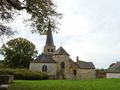
AzureWéris, which is part of Durbuy, is famous for its dolmens and menhirs. The oldest buildings in Europe are connected by several marked walkways. Wéris is also on the list of the most beautiful villages in Wallonia. Parking is preferable near the Musée du Mégalithe (V) on Place Arsène Soreil, near the fresh dump stream. Fascinating museum (daily: 10-17.30 h., www.weris-info.be) with information desk and you can also taste the traditional regional beer La Dolménius. At the statue of Mary in a niche, you enter the rue du Mont, via the circuit of the stones of legends. Immediately you get a wide view of the wide depression of the Famenne on the left. Ignore the back roads, keep walking to the crossroads of the walks at the edge of the forest. Turn right uphill towards Pierre Haina. You may first be able to walk to this other mysterious stone, the Devil's Bed, straight in front of you a few hundred meters away, and then retrace your steps. For this Pierre Haina 1 - also called Witte Menhir - it is a steep climb. It is not a real menhir, but a whitewashed rock needle, which some believe was also carved by megalith builders. Enjoy the view for a while, then stand at the top of the hill, just behind. There, at the spruce forest, a forest path begins and immediately divides into three: choose the right branch. You end up at a T, where you walk left and immediately cross an intersection. You descend to the edge of the forest and then cross a large clearing, always straight. Again, you come to a T: turn right. At the five jump you dive directly into the wood of Werris, the path follows a firebreak. On the east side of the forest, you reach a ribbon of asphalt near a mobile phone pole. Magnificent view of the Aisnedal, with your hiking destination Mormont. The left mast marks the Col de Rideux (370 m).[2] You walk to it and turn sharply to the right. A beautiful descent on asphalt to the hamlet of Bois Gérard. Underneath, you continue to walk straight, into the cul-de-sac. At the last house, you stay on the right. From here, a path between meadows descends to the valley, with new postcard panoramas along the way. Once down on the valley road, you walk to the right, in the hamlet of Laforge (Erezée). Attention: between houses 6 and 7 (left) you are looking for the narrow grass path, which behind the meadows on the Aisne with fast current (red and white sign 12). This is followed by a left-right zigzag and a very steep climb to the village. At the houses, you arrive at Rue Terre aux Loups and walk left. You go up a little further to the Place du Batty 3, the big green heart of Mormont, with picnic area and spring (not drinkable) in the middle of the grassy square. A beautiful Ardennes village, above the Aisne valley. Come back and now continue to follow Terre aux Loups Street in the other direction, so going down. It takes you to the next village in the Aisne, Fanzel. At the first houses, you take the crossing of a chapel on the left that separates from the church. A picturesque church hill 4, with atmospheric death garden. You go down to the intersection with the roundabout, at the bottom on the right. At the roundabout, turn left to cross the river. On the other bank the old water mill, now Auberge du Val d'Aisne, with terrace on the canal of the branched mill. Then cross the valley road and continue straight, in the rue de l'Affruts. It regularly climbs out of the valley, while the asphalt crumbles to gravel. Also look back from time to time. Again in the wood of Werris. Let yourself be guided through the promenade n°13, green and white. You first make a long left turn. After that, it's another kilometer of climbing, five points. Here, on the right, you continue to follow the green and white No. 13. On the ridge at the edge of the forest, there is another five jumps, you walk straight. By falling suddenly on the asphalt, you automatically return to Wéris.
See something wrong on this route?Add an issue
Navigate route in...
![]() RouteYou app Open
RouteYou app Open
![]()
Please wait, your print is being prepared.
Your print is ready to download. Have fun on the road!
Processing your request has failed. Please try again.
<iframe src="https://plugin.routeyou.com/routeviewer/free/?language=en&params.route.id=5343747" width="100%" height="600" frameborder="0" allowfullscreen></iframe>
<p><a class="routeYou_embed" href="https://app.routeyou.com/en-be/route/view/5343747?utm_source=embed&utm_medium=article&utm_campaign=routeshare&navigation=external" title="Wéris and the Aisnedal - RouteYou" target="_blank"><img src="https://image.routeyou.com/embed/route/960x670/5343747-en@2x.png" style="width: 100%; height: auto;" alt="Wéris and the Aisnedal"></a></p>
Additional feedback:
This feature is only available to RouteYou PREMIUM subscribers.
Try 1 month for free and discover the difference! We don't take any payment details, and your trial ends automatically after one month.
© 2006-2026 RouteYou - www.routeyou.com