As lies on the Kempens Plateau at an altitude of about 75 meters. It is located on the right slope of the Bosbeek valley, which is carved into the plateau here.
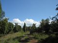
Forest and heath areas make up almost 60 percent of the area of As. Particularly in the northwest of the municipality, you can find nature reserves such as Klaverberg and the Heiderbos nature reserve. The latter is unique in Flanders due to the high concentration of juniper bushes. Nearby are also the two spoil tips of the former coal mine of Waterschei, with peaks of up to 165 meters above sea level. The spoil tips have been partially restructured and planted, and due to their special soil and slope position, they host a unique, thermophilic flora and fauna.
Departure and arrival: Schutterij Sint-Sebastiaan, Kantonnale baan, 3665 As
Vous avez remarqué quelque chose sur cet itinéraire ?Ajouter rapport
Parcourir l'itinéraire dans...
![]() Application RouteYou Ouvrez
Application RouteYou Ouvrez
Vous ne voulez plus voir cette publicité ?
→ Actualiser maintenant
![]()
Veuillez patienter, la navigation est en cours de préparation.
Vous pouvez maintenant naviguer. Bonne route !
Le traitement de la demande a échoué. Veuillez réessayer.
Vous ne voulez plus voir cette publicité ?
→ Actualiser maintenant
![]()
Veuillez patienter, votre téléchargement est en cours de préparation.
Votre téléchargement est prêt. Bonne route !
Le traitement de la demande a échoué. Veuillez réessayer.
Vous ne voulez plus voir cette publicité ?
→ Actualiser maintenant
![]()
Veuillez patienter, votre impression est en cours de préparation.
Votre impression est prête à être téléchargée. Bonne route !
Le traitement de la demande a échoué. Veuillez réessayer.
<iframe src="https://plugin.routeyou.com/routeviewer/free/?language=fr&params.route.id=6330824&params.language=en" width="100%" height="600" frameborder="0" allowfullscreen></iframe>
<p><a class="routeYou_embed" href="https://app.routeyou.com/en-be/route/view/6330824?utm_source=embed&utm_medium=article&utm_campaign=routeshare&navigation=external" title="Heiderboswanderung - As - RouteYou" target="_blank"><img src="https://image.routeyou.com/embed/route/960x670/6330824-en@2x.png" style="width: 100%; height: auto;" alt="Heiderboswanderung - As"></a></p>
Commentaires supplémentaires :
Cette fonctionnalité est exclusivement disponible pour les abonnés RouteYou PREMIUM.
Essayez 1 mois gratuit maintenant et découvrez la différence ! Nous n'exigeons aucune donnée de paiement et le service s'arrête automatiquement après votre période d'essai d'un mois.
© 2006-2026 RouteYou - www.routeyou.com