632 views | Public
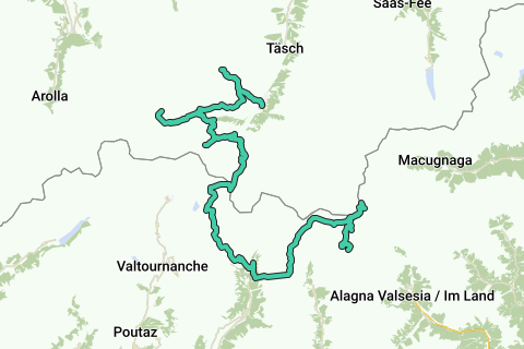
In the summer of 2012 i went on a hiking trip for two weeks; arrived at Täsh just before Zermatt and did a few hikes there before starting this adventure: an 8 day journey to the Punta Gnifetti/Signalkuppe/Rifugio Capanna Regina Margherita with a height of 4554m.
To limit the weight of my backpack i left my GPS at home so i recreated the trip using TOPOmap Schweiz and Open Street Maps.
Laps & Huts
Day 1 Jugendherberge International1 to Hotel du Trift (2337m)
Day 2 Trift (2337 M) to Schönbielhütte Sac (2694m)
Day 3 Schönbielhütte Sac (2694 M) to Hörnlihütte Sac (3260 M)
Day 4 Hörnlihütte Sac (3260 M) to Rifugio Del Teodulo Cai (3260m)
Day 5 Rifugio Teodulo CAI (3260m) to Rifugio G.B. Ferraro (2077m)
Day 6 Rifugio G.B. Ferraro (2077m) to Rifugio Quintino Sella (3600m)
Day 7 Rifugio Quintino Sella (3600m) - Rifugio Capanna Regina Margherita (4554m)
Day 8 Rifugio Capanna Regina Margherita (4554m) - Rifugio di Mantova (3497m)
Highlights
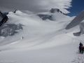
Great journey with great variety. Starting relative easily with day one heading to the Rothornhütte (3198m), day two takes you to a magnificent location near the Dent D'hérens and Dent Blanche with splendid views over the Matterhorn. Day three takes you to the foot of the Matterhorn. Day 4 is crossing the border to Italy along a ski slope to the Theodulpas. Day 5 gets you to Val d'Aoste, a greener side of the Alps with splendid nature. After a good rest at Rifugio Ferraro the serious work comes near, a heavy hike to the Rifugio Quintino Sella at a height of 3600m along a small ridge. From then on you'll need Alpine Guides to get further, we went along with Lyskamm4000. In the early morning of day 7 you'll leave the hut for an amazing Alpine adventure over the glacier to Colle Del Lys (4255m) and ends with the climb to Punta Gnifetti where the highest European hut awaits. The last day, depending on the wether and the guides you can return to Zermatt, with bad weather a return to Italy is needed.
Tips:
- Alpine Guides necessary for day 7 and 8!
- Return to Zermatt is possible but ONLY if the weather is fair and if the guides are willing to go to Zermatt. If not, you return to Val d'Aoste and a cab is needed to return to Zermatt.
- Reservations of the sleeping places is needed
- Trails up to T5-T6! (Demanding Alpine hike)
See something wrong on this route?Add an issue
Navigate route in...
![]() RouteYou app Open
RouteYou app Open
Don't want to see this ad anymore?
→ Upgrade now
![]()
Please wait, the navigation is being prepared.
You can now navigate. Have fun on the road!
Processing your request has failed. Please try again.
Don't want to see this ad anymore?
→ Upgrade now
![]()
Please wait, your download is being prepared.
Your download is ready. Have fun on the road!
Processing your request has failed. Please try again.
Don't want to see this ad anymore?
→ Upgrade now
![]()
Please wait, your print is being prepared.
Your print is ready to download. Have fun on the road!
Processing your request has failed. Please try again.
<iframe src="https://plugin.routeyou.com/routeviewer/free/?language=en&params.route.id=2259867" width="100%" height="600" frameborder="0" allowfullscreen></iframe>
<p><a class="routeYou_embed" href="https://app.routeyou.com/en-ch/route/view/2259867?utm_source=embed&utm_medium=article&utm_campaign=routeshare&navigation=external" title="Zermatt - Signalkuppe/Punta Gnifetti (4554m) - Valais/Val d'Aoste, Switzerland/Italy - RouteYou" target="_blank"><img src="https://image.routeyou.com/embed/route/960x670/2259867-en@2x.png" style="width: 100%; height: auto;" alt="Zermatt - Signalkuppe/Punta Gnifetti (4554m) - Valais/Val d'Aoste, Switzerland/Italy"></a></p>
Additional feedback:
This feature is only available to RouteYou PREMIUM subscribers.
Try 1 month for free and discover the difference! We don't take any payment details, and your trial ends automatically after one month.
© 2006-2026 RouteYou - www.routeyou.com