Stecklenberg - Wurmtal - Mailaubenkopf - Friedrichsbrunn (approx. 8 km)
This hike starts in Stecklenberg and leads on gently ascending paths to the district of Friedrichsbrunn, situated around 350 meters higher. Along the way, you will pass the historic Heerstraße, which once connected Quedlinburg and Nordhausen.
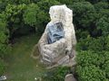
The starting point of this hike is the trail signpost at Stecklenberg Church. Following the signs for Friedrichsbrunn (green triangle), the trail initially ascends Wurmtal-Straße until reaching the Nature Friends House at the edge of the village. Proceed along the course of the Wurmbach stream until the path forks at the upper end of Wurmtalwiese. For a detour to the ruins of Lauenburg, about 500 meters away, take the path that crosses the Wurmbach to the left. However, the main route to Friedrichsbrunn continues straight ahead, still marked with the green triangle.
On well-developed forest roads, you will reach and cross Jagdhausstraße (red square), from where you immediately turn left over Mailaubenkopf until you reach the road to Friedrichsbrunn. Continue on the hiking trail parallel to the road until you reach the entrance of Friedrichsbrunn, where you turn right into Schreiberring. Turning left onto Schreiberstraße will lead you to Friedrichsbrunner Hauptstraße, which descends to the tourist information in the town center. Here you will also find the central trail signpost and the bus stop.
Bodetal-Information THALE
Bahnhofstr. 1
06502 Thale
Tel. 03947 776800
info@bodetal.de
www.bodetal.de
A36 exit Thale, continue on L240 via Warnstedt to Thale, then continue on L92 to Neinstedt, in the village continue on K2355 to Stecklenberg
Parking available on the roadside
See something wrong on this route?Add an issue
Navigate route in...
![]() RouteYou app Open
RouteYou app Open
Don't want to see this ad anymore?
→ Upgrade now
![]()
Please wait, the navigation is being prepared.
You can now navigate. Have fun on the road!
Processing your request has failed. Please try again.
Don't want to see this ad anymore?
→ Upgrade now
![]()
Please wait, your download is being prepared.
Your download is ready. Have fun on the road!
Processing your request has failed. Please try again.
Don't want to see this ad anymore?
→ Upgrade now
![]()
Please wait, your print is being prepared.
Your print is ready to download. Have fun on the road!
Processing your request has failed. Please try again.
<iframe src="https://plugin.routeyou.com/routeviewer/free/?language=en&params.route.id=14057101" width="100%" height="600" frameborder="0" allowfullscreen></iframe>
<p><a class="routeYou_embed" href="https://app.routeyou.com/en-de/route/view/14057101?utm_source=embed&utm_medium=article&utm_campaign=routeshare&navigation=external" title="From Stecklenberg to Friedrichsbrunn - RouteYou" target="_blank"><img src="https://image.routeyou.com/embed/route/960x670/14057101-en@2x.png" style="width: 100%; height: auto;" alt="From Stecklenberg to Friedrichsbrunn"></a></p>
Additional feedback:
This feature is only available to RouteYou PREMIUM subscribers.
Try 1 month for free and discover the difference! We don't take any payment details, and your trial ends automatically after one month.
© 2006-2026 RouteYou - www.routeyou.com