The western route takes us from Pforzheim to Basel. On the eastern variant described here, the trail leads over the Herzogenhorn and the Hotzenwald down to the High Rhine.
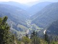
Tall mountains, deep cascading waters. Nowhere else in the German low mountain range can you climb as high as in the Black Forest. The 1493 m high mountain massif of Feldberg and Seebuck is the highest elevation of all the German low mountain ranges. The Westweg is a scenic high-altitude hike in several daily stages over this highest landmark. The route described here is the western variant, which leads over the Feldberg, the Belchen and the Blauen and finally heads for Basel. We always follow the red diamond trail markings.</p
Source: Black Forest Tourism Agency GmbH ( ©CC 4.0)
See something wrong on this route?Add an issue
Navigate route in...
![]() RouteYou app Open
RouteYou app Open
Don't want to see this ad anymore?
→ Upgrade now
![]()
Please wait, the navigation is being prepared.
You can now navigate. Have fun on the road!
Processing your request has failed. Please try again.
Don't want to see this ad anymore?
→ Upgrade now
![]()
Please wait, your download is being prepared.
Your download is ready. Have fun on the road!
Processing your request has failed. Please try again.
Don't want to see this ad anymore?
→ Upgrade now
![]()
Please wait, your print is being prepared.
Your print is ready to download. Have fun on the road!
Processing your request has failed. Please try again.
<iframe src="https://plugin.routeyou.com/routeviewer/free/?language=en&params.route.id=14058557" width="100%" height="600" frameborder="0" allowfullscreen></iframe>
<p><a class="routeYou_embed" href="https://app.routeyou.com/en-de/route/view/14058557?utm_source=embed&utm_medium=article&utm_campaign=routeshare&navigation=external" title="Westweg - Ostvariante - RouteYou" target="_blank"><img src="https://image.routeyou.com/embed/route/960x670/14058557-en@2x.png" style="width: 100%; height: auto;" alt="Westweg - Ostvariante"></a></p>
Additional feedback:
This feature is only available to RouteYou PREMIUM subscribers.
Try 1 month for free and discover the difference! We don't take any payment details, and your trial ends automatically after one month.
© 2006-2026 RouteYou - www.routeyou.com