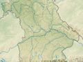
We leave the village at the Dreschhallenplatz at the lace-making school in the upper part of the village and walk slightly downhill to the end of the village, past the Amlichteich pond, to the state road. We follow it uphill to the left for just a few meters and immediately turn right again into the forest.
We walk on pleasant paths along the Buckenberg through the forest and after a good kilometer we come to the Titschengrundbach, which forms the Bavarian-Thuringian border here. Only about 400 meters further on, we are reminded of the unfortunate time of German separation when we cross the Kolonnenweg.
Now it is not far to the beautiful church and the listed baking oven in the center of Titschendorf.
Before we leave the pretty village, something should be said about its history. As already mentioned elsewhere, after the Reformation and Counter-Reformation, the Lutheran Christians who had been under pressure during the Thirty Years' War - due to various conflicts - withdrew and settled on the Titschenberg, which was still forested and under Prussian sovereignty at the time, around 1620. The settlement already had 36 houses with 58 families in 1661 and 54 in 1754. When the people of Nordhalben still say "Tierscheberch" in dialect today, it is reminiscent of the names Titschenberg or Thiersenberg, which were also common at the beginning (from the Nordhalben Chronicle). We also learn from the chronicle that the Reussian sovereign primarily wanted to offer the oppressed fellow believers a new home. However, it also came in handy that the settlers possessed special skills in all areas of wood processing and the extraction of wood and charcoal.
After this excursion into history, we continue our circular walk. We continue along the local road, then turn right and walk out into the open after the end of the village to the Echo Tree. It is said that, under favorable wind conditions, a rifle shot returns seven times as an echo here.
We continue along the field path, cross the Kolonnenweg again, enjoy the beautiful views and soon reach the Dreiherrenstein.
It once separated the Bamberg Abbey, the Margraviate of Bayreuth and the Principality of Reuß j. L. . L. . Today, Rodach and Titschengrundbach form the border between Bavaria and Thuringia.
We continue along the Rodach in the district of Grund and cross it on a footbridge to the right. We hike over a small hill, cross the Ziegengrundbach stream, carefully cross the state road and then walk very steeply uphill on the "Kapellen-" or "Vogelsteig" trail to Nordhalben. We reach the market town at the venerable Mariae Heimsuchung chapel on the slope of the Schlossberg. Now it's not far to the starting point of our hike.
<pSee something wrong on this route?Add an issue
Navigate route in...
![]() RouteYou app Open
RouteYou app Open
Don't want to see this ad anymore?
→ Upgrade now
![]()
Please wait, the navigation is being prepared.
You can now navigate. Have fun on the road!
Processing your request has failed. Please try again.
Don't want to see this ad anymore?
→ Upgrade now
![]()
Please wait, your download is being prepared.
Your download is ready. Have fun on the road!
Processing your request has failed. Please try again.
Don't want to see this ad anymore?
→ Upgrade now
![]()
Please wait, your print is being prepared.
Your print is ready to download. Have fun on the road!
Processing your request has failed. Please try again.
<iframe src="https://plugin.routeyou.com/routeviewer/free/?language=en&params.route.id=14131108" width="100%" height="600" frameborder="0" allowfullscreen></iframe>
<p><a class="routeYou_embed" href="https://app.routeyou.com/en-de/route/view/14131108?utm_source=embed&utm_medium=article&utm_campaign=routeshare&navigation=external" title="Dreiherren-Weg RT 32 - RouteYou" target="_blank"><img src="https://image.routeyou.com/embed/route/960x670/14131108-en@2x.png" style="width: 100%; height: auto;" alt="Dreiherren-Weg RT 32"></a></p>
Additional feedback:
This feature is only available to RouteYou PREMIUM subscribers.
Try 1 month for free and discover the difference! We don't take any payment details, and your trial ends automatically after one month.
© 2006-2026 RouteYou - www.routeyou.com