Flemish Mountains Route, stage 2: from Escalles to Caffiers
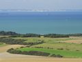
Behind the Nauw of Kales, the chalk cliffs continue deep inland in Artois. They provide an exceptional flora and endless green hills and ridges as far as the eye can see. Our second stage runs through this expansive landscape, curving around the Calais plain, with a constant view of England. You move from panorama to panorama, with the nature reserve around Mont de Couple (163 m) as the absolute highlight. A wonderful day trip!
PUBLIC TRANSPORT
* To Escalles: bus from Calais, only on weekends, info: www.sitac-calais-opale-bus.fr
* From Caffiers: train to Calais (note: very scarce service, sometimes only 1 train per day), then train to Lille-Flandres, info: www.ter.sncf.com/hauts-de-france
ASSESSMENT
Unpaved 10/10
Seclusion 9/10
Car-free 10/10
Open space 9/10
Comfort 6/10
Landscape 10/10
INFO
• http://terredes2capstourisme.fr
• www.northernfrance-tourism.com
• www.tourisme-3pays.fr
---
THE FLEMISH MOUNTAINS ROUTE, 600 KM OF HIKING FROM CALAIS TO COLOGNE
As many peaks as possible, as much unpaved, as much car-free as possible... that's the Flemish Mountain Route in a nutshell. This long-distance hike for lovers of the great outdoors and overwhelming panoramas visits all the peaks of the Flemish hill range. It will be about 600 km long and consist of around 50 daily stages of 15 to 20 km. The Flemish Mountains route leads over the green hills of Artois, through the French and West Flemish Heuvelland, over the Flemish Ardennes, through Pajottenland and Zoniën region, the Hageland, the Limburg Mining region, the Kempen Plateau, Voeren and the South Limburg Heuvelland, the Drielandenpunt and the mighty Hertogenwald.
The Flemish Mountains Route is not signposted, but will be published step by step on:
* Route You: by stage. You will find them together in the group Flemish Mountains Route. You can find the first stage here.
* Plot-a-Route: all completed stages of the Flemish Mountains Route can be downloaded from this site.
DISCLAIMER
This route has been compiled with the utmost care and, as far as the author knows, runs exclusively over public roads or private roads with permission. However, users remain responsible for their use of the roads. The author is not responsible for any violations or other problems caused by users of this route. Furthermore, the disclaimer on www.routeyou.com/nl-be/user/view/112095/wanderlust remains fully valid.
The author is not responsible for any injury, death or trespassing that may occur while practicing the outdoor activities outlined on these pages. You engage in outdoor activities at your own risk.
COPYRIGHT & CONTACT
This route is the intellectual property of the author. It may be used for personal use only, but may not be reproduced for other purposes without the author’s permission.
Contact: wanderlust@outlook.be and www.facebook.com/wanderlust.be.
See something wrong on this route?Add an issue
Navigate route in...
![]() RouteYou app Open
RouteYou app Open
Don't want to see this ad anymore?
→ Upgrade now
![]()
Please wait, the navigation is being prepared.
You can now navigate. Have fun on the road!
Processing your request has failed. Please try again.
Don't want to see this ad anymore?
→ Upgrade now
![]()
Please wait, your download is being prepared.
Your download is ready. Have fun on the road!
Processing your request has failed. Please try again.
Don't want to see this ad anymore?
→ Upgrade now
![]()
Please wait, your print is being prepared.
Your print is ready to download. Have fun on the road!
Processing your request has failed. Please try again.
<iframe src="https://plugin.routeyou.com/routeviewer/free/?language=en&params.route.id=4339100" width="100%" height="600" frameborder="0" allowfullscreen></iframe>
<p><a class="routeYou_embed" href="https://app.routeyou.com/en-fr/route/view/4339100?utm_source=embed&utm_medium=article&utm_campaign=routeshare&navigation=external" title="Flemish Mountains Route, stage 2: from Escalles to Caffiers - RouteYou" target="_blank"><img src="https://image.routeyou.com/embed/route/960x670/4339100-en@2x.png" style="width: 100%; height: auto;" alt="Flemish Mountains Route, stage 2: from Escalles to Caffiers"></a></p>
Additional feedback:
This feature is only available to RouteYou PREMIUM subscribers.
Try 1 month for free and discover the difference! We don't take any payment details, and your trial ends automatically after one month.
© 2006-2026 RouteYou - www.routeyou.com