Source: Kev747 at the English Wikipedia
Copyright: Creative Commons 3.0
240 views | Public
[Dutch text below]
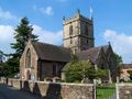
The Shropshire Hills Area of Outstanding Natural Beauty is a unique, wild hilly area in the west of England, 309 square miles large. It lies on the border with Wales and has peaks up to 507 m. In the Long Mynd, in the heart of this area, we selected a 7 miles walking loop that connects the most beautiful valleys, hilltops and panoramas. From the church of Church Stretton, you pass through Carding Mill Valley which is managed by the National Trust. Through the narrow valley, past the waterfall Lightspout, you reach a vast plateau. Along the Roman Portway, you walk softly to the highest peak of Pole Bank (507 m) from where you look out on the Welsh mountains. The descent by Townbrook Valley brings you in the lovely Old Rectory Wood, near the church of Church Stretton. In the Bucks Head Inn there you can eat and drink at reasonable prices.
RATING
Unpaved 10/10
Loneliness 8/10
Carfree 10/10
Open space 10/10
Comfort 5/10
Landscape 10/10
Panoramas 10/10
INFO
• www.shropshirehillsaonb.co.uk
• www.shropshiresgreatoutdoors.co.uk/walking
[Dutch text]
De Shropshire Hills Area Of Outstanding Natural Beauty is een uniek, wild heuvelgebied in het westen van Engeland van 800 km² groot. Het ligt tegen de grens met Wales aan en heeft toppen tot 507 m. In de Long Mynd, in het hart van dit gebied, selecteerden we een 11 km lange wandellus die de mooiste valleien, heuveltoppen en panorama’s verbindt. Van bij de kerk van Church Stretton trek je naar Carding Mill Valley dat beheerd wordt door de National Trust. Door de smalle vallei, langs de Lightspout waterval, bereik je een weidse hoogvlakte. Langs de Romeinse Portway loop je zachtjes naar de hoogste top van Pole Bank (507 m) vanwaar je uitkijkt op het Welshe berglandschap. De afdaling door Townbrook Valley brengt je tot in het mooie Old Rectory Wood, vlakbij de kerk van Church Stretton. In de Bucks Head Inn aldaar kan je lekker eten en drinken aan democratische prijzen.
BEOORDELING
Onverhard 10/10
Eenzaamheid 8/10
Autovrij 10/10
Open ruimte 10/10
Comfort 5/10
Landschap 10/10
Panorama’s 10/10
Navigate route in...
![]() RouteYou app Open
RouteYou app Open
Don't want to see this ad anymore?
→ Upgrade now
![]()
Please wait, the navigation is being prepared.
You can now navigate. Have fun on the road!
Processing your request has failed. Please try again.
Don't want to see this ad anymore?
→ Upgrade now
![]()
Please wait, your download is being prepared.
Your download is ready. Have fun on the road!
Processing your request has failed. Please try again.
Don't want to see this ad anymore?
→ Upgrade now
![]()
Please wait, your print is being prepared.
Your print is ready to download. Have fun on the road!
Processing your request has failed. Please try again.
Don't want to see this ad anymore?
→ Upgrade now
![]()
Please wait, your download is being prepared.
Your download is ready. Have fun on the road!
Processing your request has failed. Please try again.
<iframe src="https://plugin.routeyou.com/routeviewer/free/?language=en&params.route.id=4683915" width="100%" height="600" frameborder="0" allowfullscreen></iframe>
<a href="https://www.routeyou.com/en-gb/route/view/4683915/recreational-walking-route/the-long-mynd-endless-hills-of-shropshire?utm_source=embed&utm_medium=article&utm_campaign=routeshare" title="The Long Mynd, endless hills of Shropshire - RouteYou" target="_blank"><img src="https://image.routeyou.com/embed/route/960x670/4683915-en@2x.png" width="960" height="670" alt="The Long Mynd, endless hills of Shropshire"></a>
Additional feedback:
Try this feature for free with a RouteYou Plus trial subscription.
If you already have such an account, then log in now.
Try this feature for free with a RouteYou Premium trial subscription.
© 2006-2024 RouteYou - www.routeyou.com
