Source: GroeneHartstocht
At the beginning of our era, the Romans built a fort here: castellum Matilo. It is now hidden beneath the park. This archaeological treasure trove was declared a national monument in 1976. While waiting for better archaeological techniques, everything remains underground for now. To make some of the Roman past visible, a park has been laid out.
The focal point is the fort. The high earthen walls with guard towers bring it to life. You can easily step in from the Limesweg. Besides the fort and the Limesweg, there are three other areas that refer to life in and around Matilo. The patchwork of vegetable gardens depicts the once so erratic creek landscape of the Rhine. Iron retaining walls mark the banks of the Corbulo canal. The variety on the Roomburg side evokes the vibrant character of the camp village there.
Dozens of birch trees connect the different areas. They evoke memories of the old marsh forest. In this Dutch landscape, the Romans planted sweet chestnuts in strategic locations. These can now also be found at several intersections of the Limesweg in the park.
Below Park Matilo lies a whole past hidden. In 1929, archaeologists first demonstrated that the Roman fort Matilo was located at this site. From 1929 to now, various excavations and studies have been carried out in and around Matilo. The site of the castellum has been legally protected as an archaeological national monument since 1976. Since then, no more digging has been allowed. Archaeologists at most make a few viewing holes here and there to obtain important information. A large part of the remains of castellum Matilo thus remains undisturbed beneath the visitors' feet.
Only in areas around the monument where construction disturbs the soil do archaeologists conduct intensive research. They are excavating part of the camp village of Matilo for the construction of the Roomburg neighborhood. We now know exactly where the castellum is located and how large it is. Archaeologists have reconstructed this from information from old excavations and more recent measurements and borings.
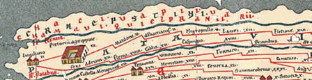
An excerpt from the Tabula Peutingeriana, a medieval copy of a Roman road map from the 4th century, showing the western route of the limes road along the Rhine. Matilo(ne) is the third fort from the mouth of the Rhine at Katwijk (Lugdunum). Map: Heritage Leiden and Surroundings, Archive Department
Source: Park Matilo
![]() | | Public | Danish • Dutch • French • German • Italian • Spanish
| | Public | Danish • Dutch • French • German • Italian • Spanish

Select one of the most popular activities below or refine your search.
Discover the most beautiful and popular trails in the area, carefully bundled into appropriate selections.
Source: GroeneHartstocht
Select one of the most popular categories below or be inspired by our selections.
Discover the most beautiful and popular attractions in the area, carefully bundled in appropriate selections.
Source: GroeneHartstocht
With RouteYou, it's easy to create your own customised maps. Simply plot your route, add waypoints or nodes, add places of interest and places to eat and drink, and then easily share it with your family and friends.
Route planner

<iframe src="https://plugin.routeyou.com/poiviewer/free/?language=en&params.poi.id=8158055" width="100%" height="600" frameborder="0" allowfullscreen></iframe>
![]()
More than 11,800,000 routes
![]()
More than 15,000,000 users
![]()
More than 4,500,000 points of interest
Kerkstraat 108
9050 Gentbrugge, Belgium
© 2006-2026 RouteYou - www.routeyou.com


