168 views | Public
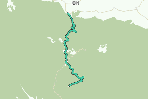
This bicycle tour brings you from the northern park entry in Pak Chong district of Nakhon Rachasima province to the highest point within the Khao Yai National Park. The tracks climbs from below 400 m up to more than 800 m over the first 5 Km. It continues up and down hill, passing the visitor center, toward the crossing at the training center. At this crossing you turn south and a couple of hundred meters further at the Ranger outpost, you turn left towards the Thai Army Control and Reporting Center (CRC) high upon Khao Khiao (aka Khao Rom). After having reached the highest view point, you descent back the same way to the cross road at the Ranger Station. Return is in the opposite way. The bicycle track is about 60+ Km long and is paved all the way. Biking takes about 4-5 hours.
Be aware that the road towards the CRC is often closed for land slides in the months September and October.
Khao Rom is a 1,351 m high mountain and the highest peak of the San Kamphaeng Range, located between Eastern Thailand and Isan. Khao Rom was also known as "Green Hill" (Khao Khiao) during the Vietnam War. In the period 23 Feb 1966 - 31 Mar 1971 there was a US military Air Defense Radar Station of the 4th Detachment of the 621 TCS (Tactical Control Squadron), Khao Khiao RTAB TH 'Dressy Lady' Control and Reporting Center (CRC), at the top of the mountain which is located roughly midway between Bangkok and Korat. The US soldiers were housed in cabins leased from Tourist Authority Thailand in a squadron area. The primary mission of the CRC was flight follow of departing/recovering tankers and B-52s to U-Tapao. On departure the CRC tracked them to a handoff point where they would go over to Lion or Brigham. Returning Lion and Brigham would hand them back to the CRC for recovery to U-Tapao. Occasionally there would be an opportunity for a tanker hook-up with departing fighters, but it was primarily flight follow. Other units at the site were STRATCOM, STRATCOM-USSAC-THAI, 1st Signal, 7th Radio Research Field Site (RRFS), 442nd Signal Battalion. The mountain is surrounded by forests and, like a great portion of the San Kamphaeng Range, it is part of the Khao Yai National Park area. The former US CRC is now run by the Royal Thai Armed Forces and is guarded by the military. Although the highest point of the mountain is not accessible to the public, there is a viewpoint near the entrance. (Sources: us-seasia.tripod.com, squawk-flash.org/dressylady/khaokhieo.htm)
A few highlights on this itinerary have been listed more for the sake of smoother navigation and referencing, although they may also appeal to many cyclists as points of interest. Individual cyclists can choose where to stop according to their own tastes and time constraints.
Who are we?
Ayutthaya Biking Adventure [ABA] is a sporting branch of Ayutthaya Historical Research. ABA’s objective is to promote bicycle tourism in Ayutthaya. Bicycling is the perfect outdoor recreation to explore Ayutthaya's city island and its surroundings. More information can be found at: http://aybiad.yolasite.com/
Disclaimer
ABA will not be held liable for any loss or damage whatsoever regarding the suggested tracks. It is the responsibility of the user to take the necessary precautions to avoid any physical injury, traffic incident, animal attack, theft, and damage to equipment. Any reliance on the ABA's information is therefore strictly at own risk. Read our full disclaimer at website http://aybiad.yolasite.com
©2011 - 2018 Ayutthaya Biking Adventure
All rights reserved.
See something wrong on this route?Add an issue
Navigate route in...
![]() RouteYou app Open
RouteYou app Open
Don't want to see this ad anymore?
→ Upgrade now
![]()
Please wait, the navigation is being prepared.
You can now navigate. Have fun on the road!
Processing your request has failed. Please try again.
Don't want to see this ad anymore?
→ Upgrade now
![]()
Please wait, your download is being prepared.
Your download is ready. Have fun on the road!
Processing your request has failed. Please try again.
Don't want to see this ad anymore?
→ Upgrade now
![]()
Please wait, your print is being prepared.
Your print is ready to download. Have fun on the road!
Processing your request has failed. Please try again.
<iframe src="https://plugin.routeyou.com/routeviewer/free/?language=en&params.route.id=1296863" width="100%" height="600" frameborder="0" allowfullscreen></iframe>
<p><a class="routeYou_embed" href="https://app.routeyou.com/en-th/route/view/1296863?utm_source=embed&utm_medium=article&utm_campaign=routeshare&navigation=external" title="Khao Yai National Park Bicycle Track 2 - RouteYou" target="_blank"><img src="https://image.routeyou.com/embed/route/960x670/1296863-en@2x.png" style="width: 100%; height: auto;" alt="Khao Yai National Park Bicycle Track 2"></a></p>
Additional feedback:
This feature is only available to RouteYou PREMIUM subscribers.
Try 1 month for free and discover the difference! We don't take any payment details, and your trial ends automatically after one month.
© 2006-2026 RouteYou - www.routeyou.com