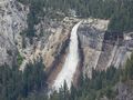
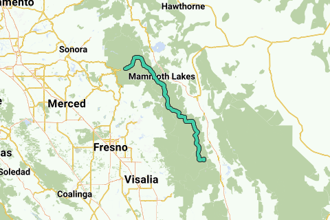
The John Muir Trail (JMT) is a long-distance trail in the Sierra Nevada mountain range of California, passing through Yosemite, Kings Canyon and Sequoia National Parks. From the northern terminus at Happy Isles in Yosemite Valley (37.7317°N 119.5587°W? / 37.7317; -119.5587? (northern terminus)) and the southern terminus located on the summit of Mount Whitney (36.5785°N 118.292°W? / 36.5785; -118.292? (southern terminus)), the Trail's official length is 210.4 miles (338.6 km). For almost all of its length, the trail is in the High Sierra backcountry and wilderness areas. For about 160 miles (260 km), the trail, named for naturalist John Muir, follows the same footpath as the longer Pacific Crest Trail.
Inspired by OSM.
See something wrong on this route?Add an issue
Navigate route in...
![]() RouteYou app Open
RouteYou app Open
Don't want to see this ad anymore?
→ Upgrade now
![]()
Please wait, the navigation is being prepared.
You can now navigate. Have fun on the road!
Processing your request has failed. Please try again.
Don't want to see this ad anymore?
→ Upgrade now
![]()
Please wait, your download is being prepared.
Your download is ready. Have fun on the road!
Processing your request has failed. Please try again.
Don't want to see this ad anymore?
→ Upgrade now
![]()
Please wait, your print is being prepared.
Your print is ready to download. Have fun on the road!
Processing your request has failed. Please try again.
<iframe src="https://plugin.routeyou.com/routeviewer/free/?language=en&params.route.id=2049024" width="100%" height="600" frameborder="0" allowfullscreen></iframe>
<p><a class="routeYou_embed" href="https://app.routeyou.com/en-us/route/view/2049024?utm_source=embed&utm_medium=article&utm_campaign=routeshare&navigation=external" title="John Muir Trail - RouteYou" target="_blank"><img src="https://image.routeyou.com/embed/route/960x670/2049024-en@2x.png" style="width: 100%; height: auto;" alt="John Muir Trail"></a></p>
Additional feedback:
This feature is only available to RouteYou PREMIUM subscribers.
Try 1 month for free and discover the difference! We don't take any payment details, and your trial ends automatically after one month.
© 2006-2026 RouteYou - www.routeyou.com