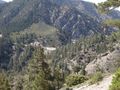
The Silver Moccasin Trail is a 53-mile (85 km) trail located in the San Gabriel Mountains, just northeast of Los Angeles. It begins at Chantry Flat Recreation Area above the city of Arcadia, California, traversing upward and down through several canyons and along the high ridges of the Angeles National Forest. This trail connects Mt. Baden-Powell, Mount Burnham, Throop Peak and Mount Hawkins. It comes to its highest point of 9,399 feet (2,865 m) at Mount Baden-Powell after which point it descends to its terminus at Vincent Gap on the Angeles Crest Highway near Wrightwood.
Inspired by OSM.
See something wrong on this route?Add an issue
Navigate route in...
![]() RouteYou app Open
RouteYou app Open
Don't want to see this ad anymore?
→ Upgrade now
![]()
Please wait, the navigation is being prepared.
You can now navigate. Have fun on the road!
Processing your request has failed. Please try again.
Don't want to see this ad anymore?
→ Upgrade now
![]()
Please wait, your download is being prepared.
Your download is ready. Have fun on the road!
Processing your request has failed. Please try again.
Don't want to see this ad anymore?
→ Upgrade now
![]()
Please wait, your print is being prepared.
Your print is ready to download. Have fun on the road!
Processing your request has failed. Please try again.
<iframe src="https://plugin.routeyou.com/routeviewer/free/?language=en&params.route.id=2056505" width="100%" height="600" frameborder="0" allowfullscreen></iframe>
<p><a class="routeYou_embed" href="https://app.routeyou.com/en-us/route/view/2056505?utm_source=embed&utm_medium=article&utm_campaign=routeshare&navigation=external" title="Silver Moccasin Trail - RouteYou" target="_blank"><img src="https://image.routeyou.com/embed/route/960x670/2056505-en@2x.png" style="width: 100%; height: auto;" alt="Silver Moccasin Trail"></a></p>
Additional feedback:
This feature is only available to RouteYou PREMIUM subscribers.
Try 1 month for free and discover the difference! We don't take any payment details, and your trial ends automatically after one month.
© 2006-2026 RouteYou - www.routeyou.com