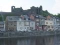
Una passeggiata segnata (rombo rosso n. 6) che inizia nel centro. I primi 4 km salgono da 200 m a 405 m di altitudine per poi scendere bruscamente per un tratto di 1 km fino a 205 m. Dopodiché si sale lentamente fino al km 10. Una passeggiata con belle panoramiche. Il percorso segue anche una parte della GR.
See something wrong on this route?Add an issue
Navigate route in...
![]() RouteYou app Open
RouteYou app Open
Don't want to see this ad anymore?
→ Upgrade now
![]()
Please wait, the navigation is being prepared.
You can now navigate. Have fun on the road!
Processing your request has failed. Please try again.
Don't want to see this ad anymore?
→ Upgrade now
![]()
Please wait, your download is being prepared.
Your download is ready. Have fun on the road!
Processing your request has failed. Please try again.
Don't want to see this ad anymore?
→ Upgrade now
![]()
Please wait, your print is being prepared.
Your print is ready to download. Have fun on the road!
Processing your request has failed. Please try again.
<iframe src="https://plugin.routeyou.com/routeviewer/free/?language=en&params.route.id=7572934&params.language=it" width="100%" height="600" frameborder="0" allowfullscreen></iframe>
<p><a class="routeYou_embed" href="https://app.routeyou.com/it-be/route/view/7572934?utm_source=embed&utm_medium=article&utm_campaign=routeshare&navigation=external" title="La roche en Ardenne (derivato) - RouteYou" target="_blank"><img src="https://image.routeyou.com/embed/route/960x670/7572934-it@2x.png" style="width: 100%; height: auto;" alt="La roche en Ardenne (derivato)"></a></p>
Additional feedback:
This feature is only available to RouteYou PREMIUM subscribers.
Try 1 month for free and discover the difference! We don't take any payment details, and your trial ends automatically after one month.
© 2006-2026 RouteYou - www.routeyou.com