Azure
Azure1. We start at the car park at the end of the
Vichteplaats.
There is 'The Narrator', a statue of Jef
Claerhout with jacquard cardboard, erected after the
merger of the textile community of Vichte into the merger
with Anzegem in 1978.
We head towards the center over the huge
cobblestone plain (an example of sterile village centre renewal) and on our left, in the middle of the greenery, the curious entrance gate of the Old Castle of the 'lords of Vichte' stands out.
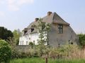
A little further on we turn into the Kerkdreef at café 'Breughel' and go left past the old Romanesque hall church with bell wall, which Goswin I of Vichte had built between 1096 and 1114. Further on on the left you have a beautiful view of the ramparts, the neerhof, the pigeon tower and the unique motte castle, whose west wing dates from the 12th century. The southeast wing was added in 1597.
This castle was the
headquarters of the lords of Vichte.
Connected to the castle was the important
title 'hereditary marshal of Flanders'. Charles
V. the future Emperor Charles would be here on May 28
1516.
2. At walking junction 4 we take the path on the right next to Vrije Bassschool De Ranke. Further on the left the vegetable garden of the schoolchildren, recently laid out in collaboration with. Nature point, and the play forest.
3. Turn left at Beukenhofstraat and continue right
at the municipal school De Beukennoot. We follow
the path next to g.c. De Stringe. On the right we have
Another play forest where the after-school care
occasionally plays. There is talk of this play forest
soon it will have to give way to the construction of a swimming pool.
In the Vlaschaardstraat we turn left.
4. After 200 meters we turn right into the
Deerlijkstraat and pass farm Het
Schaliënhof.
Next to the old castle and the old church
Het Schaliënhof is a third witness of
the rich Vichtse past. This historically important walled farm was already mentioned
on the map of Ferraris (1770-1778). The
ramparts that were preserved at the front,
now provides life to numerous plants and animals.
Even on the old walls of the entrance gate
you will find some nice plants.
Beyond Het Schaliënhof you can see a more modern view
on this old ramparts.
5. We follow the Deerlijkstraat on the left past the Mariakapelletje, with accompanying old lime tree.
6. We go straight ahead, into the Krekelheedstraat and walk about 500 meters until we see a small passage between the bushes on the left. This leads us to the green zone called the seven hills. We walk through a bit
play nature. We go straight ahead with the football field on our left and about 50 meters further we turn left and we pass a playground. This green zone that is centrally located between residential areas is therefore important for the growing youth.
At the end of the lawn (at an electricity cabin) we turn right towards Beukenhofstraat.
7. At the end of this lane you will see the entrance gate of Het Beukenhof walking junction 99).
Since 1973, this domain has been a public community asset.
Central is a neo-Renaissance castle from 1876
where a restaurant is currently operated. The castle was built by Gustaaf Moreels, great-nephew of Vital Moreels who founded the Sint-Arnolduspark in Tiegem. Both became wealthy as importers and distributors of the famous Guano fertilizers (seabird dung from Peru). The area contains older park forest edges including linden, beech, pedunculate oak, sweet chestnut, white horse chestnut and hornbeam. In the shrub layer one finds snowberry, currant, holly, yew, and rhododendron. In the herb layer you will find forest anemone, snowdrop, teatweed and pale-spored forest violet.
8. After the entrance we turn left via the walkway. We pass an ice cellar. This used to be the refrigerator of the wealthy inhabitants of the castle domain. Now this ice cellar gives shelter to bats. The mammal working group takes stock of these.
9. Beyond the bend we also see a standard fruit orchard on the left. Here you can find woodpecker holes. In addition to the great spotted woodpecker, you can often see the green woodpecker at work here. In the summer after sunset, the bats flutter above your head. A few years ago there was even a squirrel that had found its way to Het Beukenhof.
10. Follow the walkway on the right and leave the old horse stables, which are now used by the youth movement. Then take the narrow, partly overgrown walking path, with two petanque squares on the right, to the gazebo. Here we turn left towards the butterfly garden and the birth forest.
The Vichte ecological park consists of a
butterfly garden, the native forest and a zone that
is still nature expansion area. This area is a
collaboration between Natuurpunt Krekel and the
municipality of Anzegem. They take it
maintenance at their expense. The Flemish region made a considerable contribution to its realisation. The butterfly garden includes an area with butterfly-friendly shrubs and trees, a flower meadow with rising greenery and a rough one, where butterflies and insects can lay their eggs. The adjacent birth forest is a
cooperation with the family association. Every year an oak tree is planted for all boys and a linden for all girls born in that year.
11. We arrive in the Kerkdreef where we walk along the more than 3 centuries old unique knoteiken. Before the 1st WW there was no trace of buildings along this Kerkdreef. We pass the Kasselrijbeek, the former border between Kasselrij Kortrijk and Oudenaarde. Downstream, the stream was boiled in and runs up to the Oude Kerk under the concrete footpath and further left, underground until past the Beukenhofstraat. In the 70s the stream was very polluted by the steverlynck wastewater dyeing plant. Cowing was the only thing one could think of... When the ecological park is realized, we hope to be able to open the stream again. We walk 350 meters further and turn right at walking junction 4 on a slow road that runs past the old castle.
On our right, between the butterfly garden in the
Beukenhofpark and Verhaeghe Castle further on is the expansion zone of the Vigchte ecological park. The municipality is negotiating with the owners about the purchase of a plot of 3 ha from the butterfly garden to the Kasselrijbeek.
12. Halfway through this 'wegeling' you have a beautiful view on the left of the back of the old castle 'Verhaege' and the accompanying greenery. On your right, first see a piece of grassland that is partially flooded in winter. You can also find water birds here. A little further we also come across an old cattle drinking pool. The plans for the extensive ecological park also provide for a slow road along these wet meadows to the Beukenhof.
13. We walk (after the Corten steel plate with quote from Streuvels) under the railway and turn right until the Albrecht Rodenbachstraat At this point we go straight ahead, via the path along the railway and the Mekeirleweg. On the right you see an industrial zone.
14. We now turn left on the Kasselrijbeekpad, a new slow road that was created and follow it to the provincial flood basin that was built to prevent flooding in the Snoekstraat and further on in the Kerkdreef in Vichte. This wet area is a hidden gem of nature, where you can really find peace. Plant lovers, bird lovers and others will certainly be able to identify some nice species here.
15. After the provincial flood basin we turn left at the Snoekstraat. Further on you can choose:
- Or turn left for a shortened walk (5 km) and follow the sign 'centrum Vichte'. You will pass a chapel and a footpath and further on you turn into the gravel road Abeelstraat on the left and continue your way via the Albrecht Rodenbachstraat. There you will see on your left the Kasselrijbeek, formerly the Vichtebeek (after which Vichte is named) running along the row of trees. In the distance you can see the Banhoutbos.
- Or continue the walk along the Snoekstraat until you turn right at the Zavelstraat. We turn right and after 250 meters take the Ellendedreef (Walking junction 5) on the left.
16. We get past the back of Molecule. What once started as a small stove shop, ended up as a major attack on open space. This construction violation was regularized and is now a busy shopping center with beautiful asphalt parking lots!
17. We turn the Vossestraat on the right and at junction 14 and almost immediately turn left towards the N36 via the stepping stones.
18. Carefully cross the N36 and go straight ahead. You are now on a 'forgotten path'.
Frans Dejonge ensured that these and many other stepping stones towards Vichte were also included in the land of Streuvels. From this slow road you can see mills and church towers of Tiegem, Ingooigem and Vichte.
When we arrive in the Goed ter Mote street (walking junction 15) we turn left over the railway. At the Klijtberg (tee, junction 2) we turn right and continue to follow this road. We are now walking on the border between Vichte and Ingooigem.
19. At the end of the road we see The Stone Mill / radiokot
The stone mill so-called "De Jonggezellenmolen
van Yvegem" built in 1848 was initially founded as a windmill. The West Flemish Radio Broadcaster of Kortrijk had its antenna on the roof of the mill hull at the end of the 1920s and until the 2nd World War.
20. Cross diagonally left to Wijnsbergstraat. We follow this 700 meters. On our right we see the Wijnsberg, which was once a vast wooded height.
few roads were built here. The forest was cleared by the Germans in the 1st WW. There are still a few 'residual trees' left in the distance. It produces some beautiful images. Seen from the Lys, it is the first hill in the direction of the Scheldt basin.
21. On the left is a sign dead end street, which we turn into. The slow roads working group is looking at being able to hang a 'continuous street' sticker on such signs that makes it clear that this road does not end up dead for
pedestrians and cyclists.
22. We follow the Wijnsbergpad to the Delfien Vanhautestraat. This takes us to the Waregemstraat which we cross.
23. After 100 meters in the Cottereelstraat there is a small road on the left between the houses. This ends in the Lieven Bauwensstraat opposite the 'social house'). We strike here
right..
The Cottereelstraat – Lieven Bauwensstraat district was the first residential extension of Vichte in the 60s ('New Centre'). The two social housing blocks have since been demolished and are being replaced by an immense new building.
24. We turn left, walk past the new church, walk right around the pond, cross the intersection and return to the parking lot via Vichteplaats. Tip: to conclude, we come
at the end café 'Den Hert' where they serve 'Duchesse de bourgogne', real kriek beer and 'Streuvelsbier' from the local brewery Verhaeghe. Health!
This walk was designed by Nik Dooms and Pol Ostyn and previously appeared in Ivy 2016-3. All photos are by Nik Dooms.
Ivy is the member magazine of Natuur.koepel vzw. More info: http://www.natuurkoepel.be
See something wrong on this route?Add an issue
Navigate route in...
![]() RouteYou app Open
RouteYou app Open
Don't want to see this ad anymore?
→ Upgrade now
![]()
Please wait, the navigation is being prepared.
You can now navigate. Have fun on the road!
Processing your request has failed. Please try again.
Don't want to see this ad anymore?
→ Upgrade now
![]()
Please wait, your download is being prepared.
Your download is ready. Have fun on the road!
Processing your request has failed. Please try again.
Don't want to see this ad anymore?
→ Upgrade now
![]()
Please wait, your print is being prepared.
Your print is ready to download. Have fun on the road!
Processing your request has failed. Please try again.
<iframe src="https://plugin.routeyou.com/routeviewer/free/?language=en&params.route.id=4387035" width="100%" height="600" frameborder="0" allowfullscreen></iframe>
<p><a class="routeYou_embed" href="https://app.routeyou.com/en-be/route/view/4387035?utm_source=embed&utm_medium=article&utm_campaign=routeshare&navigation=external" title="Butterflies around Vichte - RouteYou" target="_blank"><img src="https://image.routeyou.com/embed/route/960x670/4387035-en@2x.png" style="width: 100%; height: auto;" alt="Butterflies around Vichte"></a></p>
Additional feedback:
This feature is only available to RouteYou PREMIUM subscribers.
Try 1 month for free and discover the difference! We don't take any payment details, and your trial ends automatically after one month.
© 2006-2026 RouteYou - www.routeyou.com