Thanks to our partner Pasar vzw you get free access to this route – and make your acquaintance with RouteYou PLUS.
Discover all benefits Azure
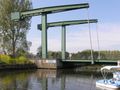
AzureStart this textbook example of a nature walk in the flat Waasland at the Church of Our Lady of the Assumption (13th century) of the Lokerse borough of Eksaarde. Around this triangular grass square, with yew trees and the first station of the Stations of the Cross, there is plenty of parking space. You step behind the church on the left onto the concrete of the Kasteeldreef and you follow, past the cemetery, to a crossroads. There you take the path on the right, with signs of the Liniewegel hiking trail (along the jagged route of a 17th-century defensive line) and the cycle path to the Kruiskapel. The larger water table on the left used to be the fence of the castle of Eksaarde. There is no getting lost, because you follow the route of this hiking trail for a large part, past fields and meadows, bushes, streams, ponds, reed beds, private domains and estates. A little further behind the reeds is the sheep barn farm. At a group of houses, the path becomes a wide earth road, where ordinary traffic is also allowed. At the green farm Den Boterhoek (1902) there is a swimming pond to the left of the road. A little further on you have the empire alone again, if you follow the signs at a crossroads on the left. Past a farm V 1 you turn left in a lane to the Kruiskapel and the white state chapels and then to the right on a path. At a picnic bench you cross the drive with the state chapels to the village. Next to the path on the left an information board about the Lokerse Natuurleerpad and behind it are Reserve plots of De Linie. Right in front of you the miraculous Chapel of the Cross from 1626 (see sign), surrounded by red beech trees. You can take a break, because along the protected chapel (open on Sunday afternoon) there are benches (and behind it a toilet block). Then follow the walking path sign past the chapel, through a protected area (dogs on a leash!). You meander along with the path, up to a T past a farm. There is a cobblestone road towards the village, but you follow the wide earth road to the left. At a large fenced villa domain with pond and ducks, the old Hooghof from 1864, you turn right into a one-way lane, where pedestrians are allowed. About 600 m further you carefully cross the concrete road Eksaarde-Sinaai. The Liniewegel sign steers you to the left, up to the drawbridge over the Moervaart. On the other side is brasserie Keysershof with terrace, on the territory of Sint-Niklaas. Before this Sinaai bridge, take the path along the Moervaart on the right, now only for pleasure boating. Beyond a wooden bridge, the asphalt turns back into a grass path. You step here a few kilometers along the Moervaart, which winds very idyllically through this quiet landscape, past pollard willows, fields, ponds and nature reserves (including a resting breeding area). At a few houses, where a ferry service used to work, and a drainage station, the footpath goes down the dike back to the village. At the drainage building (see information board) artificial nests must attract swallows again. However, continue to follow the shore, where boots are not an unnecessary luxury in winter. You arrive at the Spletterenbrug, now part of a 6.5 km long, popular walking and cycling path in a former railway bed, between Lokeren-Centrum and the Eksaarde-Moerbeke road. Up the stairs and here too a sign of the Lokerse Natuurpad. A little further the Moervaart merges with the Zuidlede, with the church of 4 3 on the left in front of you the church of Cérou-Mousty, behind you the white riding school of la Hussière. Along the Buisson des Cailloux you come to the Chemin de la Hussière. Follow it straight on until you reach a crossroads. Ignore the Sentier du Champ du Vieux Tailli on the left and continue until the next fork. Keep left and turn left again 100 m further. You now continue walking on the Chemin no. 16 - rue de Moriensart. Enjoy the 360° panorama and continue towards ferme de Morien - sart. At the fork, turn right onto the private road. Hikers are allowed to pass by. Just before the ferme de Moriensart, take the Chemin no. 59 - rue du Grand Chemin on the right. First walk to the farm for a look through the gate to the courtyard with fountain and keep from 1212. At the end of the Chemin no. 59 you come to a narrow cobblestone road. Follow it to the right and then take the first road on the left, rue des Fiefs. The asphalt turns into a gravel road and you descend to a sign with 'Chemin Nr. 18 des Fiefs'. Take the path between the fields on the right, which is lined with poles and wires. Step across the fields into a hollow road. Follow it to the left. When the hollow road stops, you step further over cobblestones. Ignore the Sentier du Marandelle on the left and continue to a complicated crossroads, with a starting sign for local walks. Walk straight ahead, cross the road to Lasne and Ohain and at place de Renival take the left the chemin Camille Lemonnier. Follow this descending cobblestone road with picturesque houses past a chapel to a fork. Ignore the Sentier no. 110 on the right and climb into the forest to the chapel with the glass door. Now follow Sentier no. 92 de la Grande Bruyère straight on until you reach your departure point. 3 Daknam in the distance. And so you left for a few kilometers through ecologically valuable area on this straight asphalt path, first high on the dike. Back in the agglomeration you cross the Weehaagstraat (right to the church). Follow the path straight through a tree drive, overlooking the village. Past a basketball court, the main street takes you right back to your starting place.
See something wrong on this route?Add an issue
Navigate route in...
![]() RouteYou app Open
RouteYou app Open
![]()
Please wait, your print is being prepared.
Your print is ready to download. Have fun on the road!
Processing your request has failed. Please try again.
<iframe src="https://plugin.routeyou.com/routeviewer/free/?language=en&params.route.id=5343469" width="100%" height="600" frameborder="0" allowfullscreen></iframe>
<p><a class="routeYou_embed" href="https://app.routeyou.com/en-be/route/view/5343469?utm_source=embed&utm_medium=article&utm_campaign=routeshare&navigation=external" title="Quiet spots along the Moervaart - RouteYou" target="_blank"><img src="https://image.routeyou.com/embed/route/960x670/5343469-en@2x.png" style="width: 100%; height: auto;" alt="Quiet spots along the Moervaart"></a></p>
Additional feedback:
This feature is only available to RouteYou PREMIUM subscribers.
Try 1 month for free and discover the difference! We don't take any payment details, and your trial ends automatically after one month.
© 2006-2026 RouteYou - www.routeyou.com