Azure
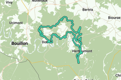
AzureTrail Le Tombeau du Chevalier (officially 55.3km, 1650 altimeters.). Version Noord Herbeumont. The GPX of this 55K trail is the exact copy of the version that was run on July 6, 2013 (see the official website http://www.festival-trail-semois.be/ for more information on this double Trail and Festival -16km; 28km; 55km-)
Exact trail data: NGI topographic maps show a flat distance to be covered 55.3 km, the number of altimeters to be climbed is 2,145 m and the actual distance covered taking into account these actual altimeters is 56.6 km. (see here an enlargement of one of my POIs: https://image.routeyou.com/shrink/fit/1024x1024/6453cb8451f8d5b814f061e35f2b5279_2445edca269ebf15540b406106bb379afbbd1bbe.jpg ).
TV-Lux made a nice report of this unique trail (mainly the 16 and 28km were filmed -the start and the end of both were the same as those of the 55K-): http://www.tvlux.be/video/festival-trail-de-la-semois_13859.html#.Ud6Lw7Ip2ps.facebook
Some departure and arrival photos can be found here: https://picasaweb.google.com/116043606535086690545/FestivalTrailSemois2013DepartsEtArrivees
This very difficult trail will make you discover the abundance of forests in the hills north of Herbeumont and Semoismeanders.
The slope pattern of this trail, but also the longer actual walking distance, the average slope and the hoagtemeters to climb (more than 425 meters more!) make this trail physically and mentally more difficult than, for example, the classic Crêtes de Spa (https://www.routeyou.com/nl/route/view/688729/wandelroute-trail-cretes-de-spa-559km.nl).
The combination of this extremely challenging 55km trail with the scorching heat was clearly visible during and after the trail. I had taken more than 5 liters of liquid, which clearly turned out to be far too little (cramps). Of the 247 starters, 191 reached the finish in reasonable conditions (http://www.festival-trail-semois.be/result2013.php ), which means that almost 1 in 4 participants did not reach the finish line. Congratulations also for them: it was an extremely difficult trail physically and mentally, where a stop after 40 km sometimes has a lot to do with wisdom.
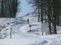
Departure to the castle of Herbeumont at 340m altitude. Some stretches cross directly through the forest to the hills (no forest trails); Some parts will even have to be climbed with hands and feet in the absence of a climbing rope.
Some descents and narrow paths also require good attention, especially in wet weather, you can easily slide a few meters.
At the end, there is a crossing of the Semois to the public natural pool (Moulain de Nawés, after 47 km). Even in summer, the current is sometimes very strong. The chance is therefore not inconceivable that you reach the right bank of the Semois much further downstream than expected. (During the trail, there is a cable that helps you stand).
Then the Tombeau du Chevalier is climbed along its southern slope towards Herbeumont. After this boult, you briefly follow the Semois, then (again...) a cross climb to the upper road with behind it the narrowed path to the castle, which, like many climbs of this path, is particularly difficult. During the trail, the castle is climbed with a ladder at the fence on its south side. In the absence of this ladder, you can continue around the castle to finish your journey.
The arrival point is located in the center of Herbeumont (Salle de Vichy) at 310m altitude.
A wonderful recommendation for the experienced athlete!
See something wrong on this route?Add an issue
Navigate route in...
![]() RouteYou app Open
RouteYou app Open
Don't want to see this ad anymore?
→ Upgrade now
![]()
Please wait, the navigation is being prepared.
You can now navigate. Have fun on the road!
Processing your request has failed. Please try again.
Don't want to see this ad anymore?
→ Upgrade now
![]()
Please wait, your download is being prepared.
Your download is ready. Have fun on the road!
Processing your request has failed. Please try again.
Don't want to see this ad anymore?
→ Upgrade now
![]()
Please wait, your print is being prepared.
Your print is ready to download. Have fun on the road!
Processing your request has failed. Please try again.
<iframe src="https://plugin.routeyou.com/routeviewer/free/?language=en&params.route.id=925399" width="100%" height="600" frameborder="0" allowfullscreen></iframe>
<p><a class="routeYou_embed" href="https://app.routeyou.com/en-be/route/view/925399?utm_source=embed&utm_medium=article&utm_campaign=routeshare&navigation=external" title="Trail Le Tombeau du Chevalier (56.6km). North Herbeumont version - RouteYou" target="_blank"><img src="https://image.routeyou.com/embed/route/960x670/925399-en@2x.png" style="width: 100%; height: auto;" alt="Trail Le Tombeau du Chevalier (56.6km). North Herbeumont version"></a></p>
Additional feedback:
This feature is only available to RouteYou PREMIUM subscribers.
Try 1 month for free and discover the difference! We don't take any payment details, and your trial ends automatically after one month.
© 2006-2026 RouteYou - www.routeyou.com