Link copied. Paste the link into Instagram to share the route.

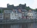
Una caminata planificada (rombo rojo nº 6) que comienza en el centro. Los primeros 4 km subimos de 200 m a 405 m de altitud para luego descender bruscamente a 205 m a lo largo de 1 km. Después, volvemos a ganar altura lentamente hasta el km 10. Una caminata con hermosos panoramas. La caminata también sigue una parte del GR.
See something wrong on this route?Add an issue
Navigate route in...
 RouteYou app Open
Don't want to see this ad anymore?
→ Upgrade now

Please wait, the navigation is being prepared.
You can now navigate. Have fun on the road!
Processing your request has failed. Please try again.
Don't want to see this ad anymore?
→ Upgrade now
Please wait, your download is being prepared.
Your download is ready. Have fun on the road!
Processing your request has failed. Please try again.
Don't want to see this ad anymore?
→ Upgrade now
Please wait, your print is being prepared.
Your print is ready to download. Have fun on the road!
Processing your request has failed. Please try again.
Additional feedback:
This feature is only available to RouteYou PREMIUM subscribers.
Try 1 month for free and discover the difference! We don't take any payment details, and your trial ends automatically after one month.
© 2006-2026 RouteYou - www.routeyou.com


 Mvraemd




 Start
 Download
 Download


