Azure
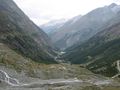
AzureL’itinéraire de haute altitude le plus attrayant et le plus impressionnant des Alpes avec vue sur Berne, le Valais et une partie des Alpes italiennes. L’itinéraire commence à la station de montagne Hannigalp (accessible par téléphérique) et mène à la chapelle. Attendez-vous à un magnifique panorama sur la vallée du Rhône et les Alpes bernoises. Pendant environ 1h30, le sentier suit la chaîne de montagnes avant de descendre dans la vallée de la Balfrin. De là, le sentier monte brièvement jusqu’à Bockwang, puis continue progressivement jusqu’à Stafelälpji au-dessus de Saas-Balen. La dernière section de l’itinéraire mène le long de la paroi rocheuse jusqu’à Saas-Fee.
See something wrong on this route?Add an issue
Navigate route in...
![]() RouteYou app Open
RouteYou app Open
Don't want to see this ad anymore?
→ Upgrade now
![]()
Please wait, the navigation is being prepared.
You can now navigate. Have fun on the road!
Processing your request has failed. Please try again.
Don't want to see this ad anymore?
→ Upgrade now
![]()
Please wait, your download is being prepared.
Your download is ready. Have fun on the road!
Processing your request has failed. Please try again.
Don't want to see this ad anymore?
→ Upgrade now
![]()
Please wait, your print is being prepared.
Your print is ready to download. Have fun on the road!
Processing your request has failed. Please try again.
<iframe src="https://plugin.routeyou.com/routeviewer/free/?language=en&params.route.id=5315082&params.language=fr" width="100%" height="600" frameborder="0" allowfullscreen></iframe>
<p><a class="routeYou_embed" href="https://app.routeyou.com/fr-ch/route/view/5315082?utm_source=embed&utm_medium=article&utm_campaign=routeshare&navigation=external" title="Grächen - Saas-Fee Höhenweg - RouteYou" target="_blank"><img src="https://image.routeyou.com/embed/route/960x670/5315082-fr@2x.png" style="width: 100%; height: auto;" alt="Grächen - Saas-Fee Höhenweg"></a></p>
Additional feedback:
This feature is only available to RouteYou PREMIUM subscribers.
Try 1 month for free and discover the difference! We don't take any payment details, and your trial ends automatically after one month.
© 2006-2026 RouteYou - www.routeyou.com