Azure
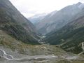
AzureDie attraktivste und eindrücklichste Höhenroute der Alpen mit Blick auf Bern, Wallis und einen Teil der italienischen Alpen. Die Route beginnt bei der Bergstation Hannigalp (erreichbar mit der Luftseilbahn) und führt hinauf zur Kapelle. Freuen Sie sich auf ein grandioses Panorama auf das Rhonetal und die Berner Alpen. Für ca. 1h30 folgt der Weg der Bergkette, bevor er ins Balfrin-Tal abfällt. Von dort steigt der Weg kurz nach Bockwang an und führt dann allmählich weiter nach Stafelälpji oberhalb von Saas-Balen. Der letzte Abschnitt der Route führt entlang der Felswand hinunter nach Saas-Fee.
See something wrong on this route?Add an issue
Navigate route in...
![]() RouteYou app Open
RouteYou app Open
Don't want to see this ad anymore?
→ Upgrade now
![]()
Please wait, the navigation is being prepared.
You can now navigate. Have fun on the road!
Processing your request has failed. Please try again.
Don't want to see this ad anymore?
→ Upgrade now
![]()
Please wait, your download is being prepared.
Your download is ready. Have fun on the road!
Processing your request has failed. Please try again.
Don't want to see this ad anymore?
→ Upgrade now
![]()
Please wait, your print is being prepared.
Your print is ready to download. Have fun on the road!
Processing your request has failed. Please try again.
<iframe src="https://plugin.routeyou.com/routeviewer/free/?language=en&params.route.id=5315082&params.language=de" width="100%" height="600" frameborder="0" allowfullscreen></iframe>
<p><a class="routeYou_embed" href="https://app.routeyou.com/de-ch/route/view/5315082?utm_source=embed&utm_medium=article&utm_campaign=routeshare&navigation=external" title="Grächen - Saas-Fee Höhenweg - RouteYou" target="_blank"><img src="https://image.routeyou.com/embed/route/960x670/5315082-de@2x.png" style="width: 100%; height: auto;" alt="Grächen - Saas-Fee Höhenweg"></a></p>
Additional feedback:
This feature is only available to RouteYou PREMIUM subscribers.
Try 1 month for free and discover the difference! We don't take any payment details, and your trial ends automatically after one month.
© 2006-2026 RouteYou - www.routeyou.com