Link copied. Paste the link into Instagram to share the route.

Ruta de las Dunas Anchas 45 km
Disponible: todo el año.
Provincia:
Noord-Holland Rutas en bicicleta en Noord-Holland
Lugares:
Alkmaar
Groet
Schoorl
Bergen nh
La Ruta de las Dunas Anchas es una experiencia que debe vivir al menos una vez. En Bergen y Schoorl se encuentra posiblemente la ruta en bicicleta más hermosa de los Países Bajos. Con el aire fresco del mar, la hermosa naturaleza y diferentes aldeas, esta ruta ha sido acertadamente elegida como la más hermosa por los lectores de ANWB Kampioen.
Alturas elevadas, valles profundos
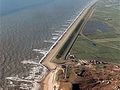
Al pedalear, experimentará que este título no es casual. En combinación con un fuerte viento holandés y cumbres de dunas de 54 m de altura, puede ser una ruta exigente que, además de dunas, transcurre por bosques, brezales, pólderes y encantadoras aldeas como Groet, Camperduin, Schoorl y Bergen. Gracias a esta zona de dunas, es una ruta con un cierto desnivel y tiene aproximadamente 5 kilómetros de ancho entre Bergen y Schoorl. Al salir de la zona de dunas, llega a la Hondsbosche Zeewering; la dársena que protege el interior de la costa contra el mar del Norte. Justo detrás del dique se encuentra la reserva de aves De Putten. En las aldeas mencionadas anteriormente puede relajarse un rato en una terraza.
La ruta tiene aproximadamente 45 km de longitud, sin embargo, tiene una señalización deficiente. Las señales especiales de la Ruta de las Dunas Anchas suelen estar sucias, lo que dificulta ver la dirección a tiempo. Están ubicadas en lugares aleatorios en las intersecciones; cerca del suelo en pequeños postes, (faroles), postes, cercas, altos y bajos o, en algunos casos, ni siquiera están presentes. Se recomienda el uso de mapas detallados.
¡ATENCIÓN! La intersección Hondsboscheweg / Leiweg / Westerduinweg es conocida por ser muy peligrosa. Debe cruzar una carretera para automóviles. Si bien hay poco tráfico, este circula más rápido que la velocidad permitida.
See something wrong on this route?Add an issue
Navigate route in...
 RouteYou app Open
Don't want to see this ad anymore?
→ Upgrade now

Please wait, the navigation is being prepared.
You can now navigate. Have fun on the road!
Processing your request has failed. Please try again.
Don't want to see this ad anymore?
→ Upgrade now
Please wait, your download is being prepared.
Your download is ready. Have fun on the road!
Processing your request has failed. Please try again.
Don't want to see this ad anymore?
→ Upgrade now
Please wait, your print is being prepared.
Your print is ready to download. Have fun on the road!
Processing your request has failed. Please try again.
Additional feedback:
This feature is only available to RouteYou PREMIUM subscribers.
Try 1 month for free and discover the difference! We don't take any payment details, and your trial ends automatically after one month.
© 2006-2026 RouteYou - www.routeyou.com


 Nighthawk650




 Start
 Download
 Download


