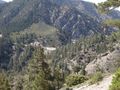
Het Silver Moccasin Trail is een 53 mijl (85 km) lang pad gelegen in de San Gabriel Mountains, net ten noordoosten van Los Angeles. Het begint bij het Chantry Flat Recreatiegebied boven de stad Arcadia, Californië, en loopt omhoog en omlaag door verschillende kloven en langs de hoge bergen van het Angeles National Forest. Dit pad verbindt Mt. Baden-Powell, Mount Burnham, Throop Peak en Mount Hawkins. Het bereikt zijn hoogste punt van 9.399 voet (2.865 m) bij Mount Baden-Powell, waarna het afdaalt naar het eindpunt bij Vincent Gap op de Angeles Crest Highway nabij Wrightwood.
geïnspireerd door OSM.
See something wrong on this route?Add an issue
Navigate route in...
![]() RouteYou app Open
RouteYou app Open
Don't want to see this ad anymore?
→ Upgrade now
![]()
Please wait, the navigation is being prepared.
You can now navigate. Have fun on the road!
Processing your request has failed. Please try again.
Don't want to see this ad anymore?
→ Upgrade now
![]()
Please wait, your download is being prepared.
Your download is ready. Have fun on the road!
Processing your request has failed. Please try again.
Don't want to see this ad anymore?
→ Upgrade now
![]()
Please wait, your print is being prepared.
Your print is ready to download. Have fun on the road!
Processing your request has failed. Please try again.
<iframe src="https://plugin.routeyou.com/routeviewer/free/?language=en&params.route.id=2056505&params.language=nl" width="100%" height="600" frameborder="0" allowfullscreen></iframe>
<p><a class="routeYou_embed" href="https://app.routeyou.com/nl-us/route/view/2056505?utm_source=embed&utm_medium=article&utm_campaign=routeshare&navigation=external" title="Zilveren Moccassinpunt - RouteYou" target="_blank"><img src="https://image.routeyou.com/embed/route/960x670/2056505-nl@2x.png" style="width: 100%; height: auto;" alt="Zilveren Moccassinpunt"></a></p>
Additional feedback:
This feature is only available to RouteYou PREMIUM subscribers.
Try 1 month for free and discover the difference! We don't take any payment details, and your trial ends automatically after one month.
© 2006-2026 RouteYou - www.routeyou.com