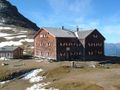
This circular hike leads through high-alpine landscape from the Lucknerhaus at the end of the Kals Glockner Road to the Glorer Hütte at the foot of the Großglockner, Austria's highest peak. The hut also marks the starting point of the Geomorphological Learning Trail, a walking route with information stations telling visitors about the wonderfully diverse flora and fauna of the Hohe Tauern Mountains. The hike has no major technical difficulties and is relatively easy to negotiate, though walkers should be sure-footed.
This hike begins at the Lucknerhaus (1,920 metres) at the end fo the Kals Glockner Road. From the first information station of the Geomorphological Learning Trail, follow the signs for the "Glorer Hütte" and head south to the Schliederle-Alm (you will cross under the small cable car used to transport provisions up to the hut). Right at the start of the hike you will be greeted by fine views of the Ködnitztal Valley, with the Großglockner mountain towering high above. Continue along the Bergerbach stream, underneath the material cable car, along the learning trail heading uphill. Take your time to read the information boards about the flora and fauna of the region.
Source: Visit Tirol
See something wrong on this route?Add an issue
Navigate route in...
![]() RouteYou app Open
RouteYou app Open
Don't want to see this ad anymore?
→ Upgrade now
![]()
Please wait, the navigation is being prepared.
You can now navigate. Have fun on the road!
Processing your request has failed. Please try again.
Don't want to see this ad anymore?
→ Upgrade now
![]()
Please wait, your download is being prepared.
Your download is ready. Have fun on the road!
Processing your request has failed. Please try again.
Don't want to see this ad anymore?
→ Upgrade now
![]()
Please wait, your print is being prepared.
Your print is ready to download. Have fun on the road!
Processing your request has failed. Please try again.
<iframe src="https://plugin.routeyou.com/routeviewer/free/?language=en&params.route.id=15259309" width="100%" height="600" frameborder="0" allowfullscreen></iframe>
<p><a class="routeYou_embed" href="https://app.routeyou.com/en-at/route/view/15259309?utm_source=embed&utm_medium=article&utm_campaign=routeshare&navigation=external" title="Ködnitztal - Glorer Hütte - RouteYou" target="_blank"><img src="https://image.routeyou.com/embed/route/960x670/15259309-en@2x.png" style="width: 100%; height: auto;" alt="Ködnitztal - Glorer Hütte"></a></p>
Additional feedback:
This feature is only available to RouteYou PREMIUM subscribers.
Try 1 month for free and discover the difference! We don't take any payment details, and your trial ends automatically after one month.
© 2006-2026 RouteYou - www.routeyou.com