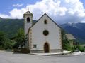
Austria's highest peak, the Großglockner, accompanies hikers at every turn on this beautiful trail with fabulous views of the Virgental Valley all the way to the glaciers of the Venediger Mountains. The adventure begin with a ride up on the Goldriedbahn cable car into the mountains. From the top of the cable car, the Großglockner (3,798 metres) seems almost close enough to touch. Hikers then head along a trail from the Kals-Matreier-Törl and the Bergstation Blauspitz with a number of information boards about the flora and fauna of the Alps. There is another learning trail at the Gasthaus Glocknerblick restaurant, this time about herbs and plants. The gothic parish church in the village of Kals is also worth a visit. The church is dedicted to Saint Rupert and is one of the earliest in the area, dating to the reign of Chalmemagne (8th/9th century).
From the small town of Matrei take the Goldried-Bergbahn cable car up to the top station. It is there that this hike begins. Follow the signs for "Kals-Matreier-Törl, Europa- Panoramaweg". The first section heads very slightly uphill and then very slightly downhill to the Kals-Matreier Törl (2,204 metres), a good place for a break and a snack. From there, continue along the trail towards the "Panoramarestaurant Blauspitz, Panoramaweg Nr. 26". The next section is more or less flat across open meadows towards the Großglockner mountain, before getting steeper. At the fork in the trail, follow the signs for "Panoramarestaurant Blauspitz" and keep walking uphill. At the next fork in the trail, head back downhill to the Bergstation Blauspitz (which you will already be able to see). Just a little behind the Panoramarestaurant Blauspitz you will find a trail winding its way down along a series of switchback corners through the ski resort. The trail then becomes wider on and next to the ski piste. Keep heading towards the Gedächtniskapelle chapel (which you will already be able to see). Shortly before you get to the chapel you will reach a fork in the trail. Take the right-hand fork ("Kals/Großdorf") and – following the markings – head past the chapel. Then return to the piste and continue to the Bergrestaurant Glocknerblick. From there, keep heading down to the mid-way station of the chairlift. Take trail 516 to the settlement of Großdorf near Kals. In Großdorf, follow the signs for "Glor über Wiesenweg". You will cross the Kalser Bach stream. Continue through the fields and meadows to Kals and the National Park information station at the Glocknerhaus next to the parish church.
Source: Visit Tirol
See something wrong on this route?Add an issue
Navigate route in...
![]() RouteYou app Open
RouteYou app Open
Don't want to see this ad anymore?
→ Upgrade now
![]()
Please wait, the navigation is being prepared.
You can now navigate. Have fun on the road!
Processing your request has failed. Please try again.
Don't want to see this ad anymore?
→ Upgrade now
![]()
Please wait, your download is being prepared.
Your download is ready. Have fun on the road!
Processing your request has failed. Please try again.
Don't want to see this ad anymore?
→ Upgrade now
![]()
Please wait, your print is being prepared.
Your print is ready to download. Have fun on the road!
Processing your request has failed. Please try again.
<iframe src="https://plugin.routeyou.com/routeviewer/free/?language=en&params.route.id=15262253" width="100%" height="600" frameborder="0" allowfullscreen></iframe>
<p><a class="routeYou_embed" href="https://app.routeyou.com/en-at/route/view/15262253?utm_source=embed&utm_medium=article&utm_campaign=routeshare&navigation=external" title="Matrei i. Osttirol - Kals-Matreier-Törl-Haus - Glocknerhaus Kals - RouteYou" target="_blank"><img src="https://image.routeyou.com/embed/route/960x670/15262253-en@2x.png" style="width: 100%; height: auto;" alt="Matrei i. Osttirol - Kals-Matreier-Törl-Haus - Glocknerhaus Kals"></a></p>
Additional feedback:
This feature is only available to RouteYou PREMIUM subscribers.
Try 1 month for free and discover the difference! We don't take any payment details, and your trial ends automatically after one month.
© 2006-2026 RouteYou - www.routeyou.com