Thanks to our partner Gemeente Kortenberg you get free access to this route – and make your acquaintance with RouteYou PLUS.
Discover all benefitsThe Heuveling hike owes its name to Heuveling or Groß-Heuveling, a field complex located between the Brussels-Leuven railway line, Everbergstraat, Kwerpsebaan, and Oudebaan.
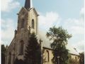
Our walk begins at the village square in Erps-Kwerps at the Sint Amandus Church. There is parking available for those arriving by car. Behind the church lies Paddestraat or Footpath 69. We take this street, which is designated for pedestrians and cyclists only. This leads us to Oudebaan. We turn right and walk until we reach Klapstraat, at the corner of Hof ter Netelen or the Pelgrims Pachtshof. Opposite, you can see the beautiful baroque chapel of Our Lady of Help. We continue straight along Oudebaan. This takes us to Kwerpsebaan, which we cross. At the corner, on the left, we see Rijckenberghoeve, commonly known as the Pachtshof of 'Lammeke Wauters'. We follow Oudebaan or Neighborhood Path 7, keep right (so we do not go into Vilvoordsebaan) and thus reach the Heuveling field complex. We come to Zuurbeek, where we take Neighborhood Path 25 on the right. A little further at the Y-junction, we keep right and take Neighborhood Path 8 or Schoonaardeweg. We reach Zavelstraat, which we cross and follow Neighborhood Path 8 until we get to Kwerpsebaan. We turn left and at the first intersection, we turn right into Everbergstraat to reach Engerstraat. We turn right and a little further, turn left into Footpath 61. Through this path, we cross Weesbeek and thus arrive in Kammestraat. We go right and at the house of Jan van Ransem (number 7), we turn left into the small Kammestraat to reach Peperstraat. We turn right and thus return to the village square, the starting point of the Heuveling hike.
See something wrong on this route?Add an issue
Navigate route in...
![]() RouteYou app Open
RouteYou app Open
![]()
Please wait, your print is being prepared.
Your print is ready to download. Have fun on the road!
Processing your request has failed. Please try again.
<iframe src="https://plugin.routeyou.com/routeviewer/free/?language=en&params.route.id=673561" width="100%" height="600" frameborder="0" allowfullscreen></iframe>
<p><a class="routeYou_embed" href="https://app.routeyou.com/en-be/route/view/673561?utm_source=embed&utm_medium=article&utm_campaign=routeshare&navigation=external" title="Hill hiking - RouteYou" target="_blank"><img src="https://image.routeyou.com/embed/route/960x670/673561-en@2x.png" style="width: 100%; height: auto;" alt="Hill hiking"></a></p>
Additional feedback:
This feature is only available to RouteYou PREMIUM subscribers.
Try 1 month for free and discover the difference! We don't take any payment details, and your trial ends automatically after one month.
© 2006-2026 RouteYou - www.routeyou.com