Stecklenberg - Stecklenburg - Lauenburg - Wurmbachtal - Stecklenberg (approx. 4.5 km)
This circular hiking trail starting and ending in Stecklenberg is relatively short, but with a total of around 150 meters in altitude, it includes some quite steep climbs. However, these are worth it because in addition to a magnificent view over the town, this hike also offers the remains of two former castles.
The starting point of this hike is the hiking trail signpost opposite the Stecklenberg church. Following the green bar and crown markings on the left side of the municipal office, you will soon pass the Giant Slide.
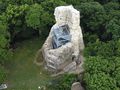
Now the path leads steeply uphill to the Pulpit under the large oak tree, and then a few more meters steeply uphill to the ruins of Stecklenburg. From here, you have a beautiful view of the town of Stecklenberg and all the way to the Devils Wall in Weddersleben. Alternatively, you can also choose the path through the spa park and walk to the Stecklenburg via the Calcium Spring (approx. 1.3 km).
From the Stecklenburg, follow the hiking trail with the aforementioned markings to Lauenburg, where the home of the Paritätischer Wohlfahrtsverband and a viewpoint with a beautiful view of the Harz Foreland and up to Quedlinburg are located. From here, a short detour to the ruins of the former main castle is worthwhile. To do this, walk back about 200 meters on the hiking trail and then uphill on a narrow and somewhat challenging path that branches off to the right of the trail. One of the rewards for this effort is an old lime tree that has anchored its roots in the old stonework.
From the viewpoint at the home, you will pass by an information board about the history of Lauenburg and the former tower of the outer bailey. Then, after a few meters, you will reach a crossroads with a signpost and then hike back to Stecklenberg via the Wurmbachtal (blue dot). From the bridge over the Wurmbach, the path along the stream is recommended. This path is especially beautiful when the stream has sufficient water.
Bodetal-Information THALE
Bahnhofstraße 1
06502 Thale
Tel. 03947 7768000
info@bodetal.de
www.bodetal.de
B6n exit Thale, continue on the L240 via Warnstedt to Thale, then continue on the L92 to Neinstedt, in the village continue on the K2355 to Stecklenberg
Parking available on the roadside or at the Angelteich in Wurmtal
See something wrong on this route?Add an issue
Navigate route in...
![]() RouteYou app Open
RouteYou app Open
Don't want to see this ad anymore?
→ Upgrade now
![]()
Please wait, the navigation is being prepared.
You can now navigate. Have fun on the road!
Processing your request has failed. Please try again.
Don't want to see this ad anymore?
→ Upgrade now
![]()
Please wait, your download is being prepared.
Your download is ready. Have fun on the road!
Processing your request has failed. Please try again.
Don't want to see this ad anymore?
→ Upgrade now
![]()
Please wait, your print is being prepared.
Your print is ready to download. Have fun on the road!
Processing your request has failed. Please try again.
<iframe src="https://plugin.routeyou.com/routeviewer/free/?language=en&params.route.id=14057155" width="100%" height="600" frameborder="0" allowfullscreen></iframe>
<p><a class="routeYou_embed" href="https://app.routeyou.com/en-de/route/view/14057155?utm_source=embed&utm_medium=article&utm_campaign=routeshare&navigation=external" title="Circular hike around Stecklenberg - RouteYou" target="_blank"><img src="https://image.routeyou.com/embed/route/960x670/14057155-en@2x.png" style="width: 100%; height: auto;" alt="Circular hike around Stecklenberg"></a></p>
Additional feedback:
This feature is only available to RouteYou PREMIUM subscribers.
Try 1 month for free and discover the difference! We don't take any payment details, and your trial ends automatically after one month.
© 2006-2026 RouteYou - www.routeyou.com