Stecklenberg – Stecklenburg – Lauenburg – Wurmbachtal – Stecklenberg (aprox. 4,5 km)
Este sendero circular que comienza y termina en Stecklenberg es relativamente corto, pero cuenta con unas pendientes bastante pronunciadas que suman un total de alrededor de 150 metros de altitud. Sin embargo, vale la pena, ya que además de una hermosa vista sobre el lugar, esta caminata también ofrece los restos de dos antiguas fortalezas.
El punto de partida de esta caminata es el árbol de señales del sendero frente a la iglesia de Stecklenberg. A la izquierda, siguiendo la marca de la barra verde y la corona, pasará poco después por el tobogán gigante.
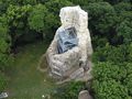
El camino sube empinadamente hasta el púlpito debajo del gran roble y luego, de nuevo, algunos metros hacia arriba hasta las ruinas de Stecklenburg. Desde aquí se tiene una hermosa vista de Stecklenberg y hasta la Teufelsmauer en Weddersleben. Alternativamente, también puede elegir el camino a través del parque termal y caminar hasta Stecklenburg pasando por la fuente de calcio (aprox. 1,3 km).
Desde Stecklenburg, siga el sendero con la marca mencionada hasta Lauenburg, donde se encuentra el hogar de la Asociación Paritaria de Bienestar y un mirador con una bonita vista sobre el Harz y hasta Quedlinburg. Desde aquí, vale la pena hacer una pequeña desviación hacia las ruinas de la antigua fortaleza principal. Para ello, regrese por el sendero aproximadamente 200 metros y luego suba por un sendero estrecho y algo difícil que se desvía a la derecha del sendero. La recompensa por el esfuerzo es, entre otras cosas, un viejo tilo que se ha anclado con sus raíces en la antigua muralla.
Desde el mirador en el hogar, pasará por un panel informativo sobre la historia de Lauenburg y por la antigua torre del recinto exterior. Luego, después de algunos metros, llegará a una intersección de caminos con un árbol de señales y volverá a caminar hacia Stecklenberg a través del Wurmbachtal (punto azul). A partir del puente sobre el Wurmbach, el sendero a lo largo del arroyo merece la pena. Este camino es especialmente bonito cuando el arroyo lleva suficiente agua.
Bodetal-Information THALE
Bahnhofstraße 1
06502 Thale
Tel. 03947 7768000
info@bodetal.de
www.bodetal.de
B6n Salida Thale, continuar por la L240 a través de Warnstedt hacia Thale, luego seguir por la L92 hacia Neinstedt, en la localidad continuar por la K2355 hacia Stecklenberg
Posibilidades de aparcamiento al borde de la carretera o en Wurmtal en el estanque de pesca
See something wrong on this route?Add an issue
Navigate route in...
![]() RouteYou app Open
RouteYou app Open
Don't want to see this ad anymore?
→ Upgrade now
![]()
Please wait, the navigation is being prepared.
You can now navigate. Have fun on the road!
Processing your request has failed. Please try again.
Don't want to see this ad anymore?
→ Upgrade now
![]()
Please wait, your download is being prepared.
Your download is ready. Have fun on the road!
Processing your request has failed. Please try again.
Don't want to see this ad anymore?
→ Upgrade now
![]()
Please wait, your print is being prepared.
Your print is ready to download. Have fun on the road!
Processing your request has failed. Please try again.
<iframe src="https://plugin.routeyou.com/routeviewer/free/?language=en&params.route.id=14057155&params.language=es" width="100%" height="600" frameborder="0" allowfullscreen></iframe>
<p><a class="routeYou_embed" href="https://app.routeyou.com/es-de/route/view/14057155?utm_source=embed&utm_medium=article&utm_campaign=routeshare&navigation=external" title="Ronda alrededor de Stecklenberg - RouteYou" target="_blank"><img src="https://image.routeyou.com/embed/route/960x670/14057155-es@2x.png" style="width: 100%; height: auto;" alt="Ronda alrededor de Stecklenberg"></a></p>
Additional feedback:
This feature is only available to RouteYou PREMIUM subscribers.
Try 1 month for free and discover the difference! We don't take any payment details, and your trial ends automatically after one month.
© 2006-2026 RouteYou - www.routeyou.com