Already in the Middle Ages, an army and trade route led from Bremen to Amsterdam through the settlement area of early Nordhorn. As early as 1160, sandstones from Bentheim were shipped to the Netherlands from Nordhorn. The returning ships brought back spices, textiles, cocoa, tobacco, tea, and other goods. At its peak, up to 1,200 cargo cranes and ships were anchored in Nordhorn. At that time, Nordhorn was the residence of wealthy merchants, ship owners, and sailors.
The Vechte, which is almost 170 km long, still had direct access to the sea in the Middle Ages and for many centuries was the center of Dutch maritime trade. With the completion of the Nordhorn-Almelo Canal in 1904, the connection to the Dutch waterway network was finally established.
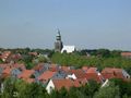
If hikers follow the course of the Vechte further north, they will come across the Frenswegen Monastery, which now serves as an ecumenical meeting place.
If you continue westward, you will reach small forest paths leading to the old border road separating the Netherlands and Germany. From here, you can explore forest and heathland areas all the way to the Dutch nature reserve De Bergvennen. It is home to a variety of rare animal and plant species, such as the great crested newt, the common lizard, the adder, and the woodlark.
Note: Follow the orange signage!
Navigate route in...
![]() RouteYou app Open
RouteYou app Open
![]()
Please wait, your print is being prepared.
Your print is ready to download. Have fun on the road!
Processing your request has failed. Please try again.
<iframe src="https://plugin.routeyou.com/routeviewer/free/?language=en&params.route.id=14124177" width="100%" height="600" frameborder="0" allowfullscreen></iframe>
<p><a class="routeYou_embed" href="https://www.routeyou.com/en-de/route/view/14124177?utm_source=embed&utm_medium=article&utm_campaign=routeshare" title="County Tracing - On the Trails of Old Waterways - RouteYou" target="_blank"><img src="https://image.routeyou.com/embed/route/960x670/[email protected]" width="960" height="670" alt="County Tracing - On the Trails of Old Waterways"></a></p>
Additional feedback:
Try this feature for free with a RouteYou Plus trial subscription.
If you already have such an account, then log in now.
Try this feature for free with a RouteYou Premium trial subscription.
If you already have such an account, then log in now.
© 2006-2024 RouteYou - www.routeyou.com