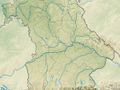
The Dreiwappenweg is a hiking trail of pleasant paths and tranquillity; we only encounter civilization in Grumbach and at the beginning and end of the hike, otherwise we enjoy the seclusion and natural silence of vast forest areas. The encounter with the recent past is also impressive, as we hike for a long time on the Kolonnenweg along the former death strip that separated our homeland after 1945. Those in the know will also find the fauna and flora of the Green Belt interesting. Our main circular trail also touches on the past of rafting in Ködelgrund and the Rennsteig trail, which is shrouded in legends.
Our hike begins at the Wanderbares Deutschland starting point at the lace-making school. We follow Amlichstraße up to Lobensteiner Straße and leave it to the left on the Fichtera-Weg (RT31) after the last houses at the northern end of the village. Our hiking trail splits here.
We walk along a field path over the Galgenberg to the forest. We walk down the Teufelsberg on a path and continue along a small rivulet to Alte Tschirner Straße. Here we cross the Alte Tschirner Brücke bridge over the Nordhalbener Ködel and its pristine ground in the nature reserve.
Immediately opposite, we walk steeply uphill in the forest for about half a kilometer until we reach a forest path that branches off to the right. We use it to circle the ridge of the Kaimleite in an arc with occasional views along the grassy path. We cross the Nordhalben-Tschirn state road and follow a forest path gently uphill. The Rosenbaumbach stream, which forms the border between Bavaria and Thuringia, accompanies us in its unspoilt valley floor at varying distances. Over there you can see the Thuringian forest area Großer Brand, to our left is the Bavarian state forest Haselwiese. We keep to the right until we reach the Hohe Tanne forest area and then turn north again. Shortly before the former location of the Dreiwappenstein (it disappeared in the turmoil of the post-war period), we come to the Rennsteig.
Following the Rennsteig on a detour (about 1 km easy) to the left, we reach the cemetery on the outskirts of Brennersgrün via the former death strip and a beautiful view of the village and the Wetzstein with the Altvaterturm tower.
But with the Rennsteig trail in the forest to the right, we reach the edge of the Hohe Tanne forest area after a long time on near-natural paths. We walk along the Eisensteinstraße at the edge of the forest to the connecting road leading to Brennersgrün. It leads us to Grumbach on the right.
This village was founded as a glassworks in 1616 by the settlement of two Swabian families, Greiner and Müller, who had been expelled because of their faith, after signing a contract with the Prussian princely family. Later, the princes of the younger Reuss line also resided in the village, which is situated at an altitude of 667 to 724 meters above sea level in the Prussian Oberland. The name Grumbach does not appear until 1713, before that the settlement was simply called Glashütte.
Through the village and past the Zum Frankenwald restaurant, we reach the edge of the forest and keep left on the forest path to the narrow valley of the Grumbach stream. The Fuchsengrund flows in from the north-east at the Grumbacher Floßteich. Later the Seligenstädter Grund. This is named after the village of Seligenstadt, which was mentioned in the 13th century and later abandoned. As we now hike for a long time in the forest on the already somewhat grassy Kolonnenweg along the former, already overgrown death strip to the Rodacherbrunn-Nordhalben road, we feel transported back to the time of the division of Germany. We cross the border on the road, but immediately turn left again and soon reach a forest path in the Katzenzipfel forest section.
We follow this for around 200 m until we branch off to the right onto a natural, pleasant forest path and soon meet the Wiesenpanoramaweg. At the edge of the forest before Buckenreuth, the view sweeps over the beautiful, rugged landscape. Both paths lead along the edge of the wall in a southerly direction. When the Wiesenpanoramaweg leaves us to the right, we go straight on into the forest. There we come to a forest path, which we follow to the right. We pass a paddock and recognize the riding stable on the right. After about 500 m we reach the Nordhalben natural adventure pool. We cross the road straight ahead and pass the first houses in Nordhalben.
See something wrong on this route?Add an issue
Navigate route in...
![]() RouteYou app Open
RouteYou app Open
Don't want to see this ad anymore?
→ Upgrade now
![]()
Please wait, the navigation is being prepared.
You can now navigate. Have fun on the road!
Processing your request has failed. Please try again.
Don't want to see this ad anymore?
→ Upgrade now
![]()
Please wait, your download is being prepared.
Your download is ready. Have fun on the road!
Processing your request has failed. Please try again.
Don't want to see this ad anymore?
→ Upgrade now
![]()
Please wait, your print is being prepared.
Your print is ready to download. Have fun on the road!
Processing your request has failed. Please try again.
<iframe src="https://plugin.routeyou.com/routeviewer/free/?language=en&params.route.id=14130794" width="100%" height="600" frameborder="0" allowfullscreen></iframe>
<p><a class="routeYou_embed" href="https://app.routeyou.com/en-de/route/view/14130794?utm_source=embed&utm_medium=article&utm_campaign=routeshare&navigation=external" title="Dreiwappen-Weg HRW 5 - RouteYou" target="_blank"><img src="https://image.routeyou.com/embed/route/960x670/14130794-en@2x.png" style="width: 100%; height: auto;" alt="Dreiwappen-Weg HRW 5"></a></p>
Additional feedback:
This feature is only available to RouteYou PREMIUM subscribers.
Try 1 month for free and discover the difference! We don't take any payment details, and your trial ends automatically after one month.
© 2006-2026 RouteYou - www.routeyou.com