Thanks to our partner Dromos you get free access to this route – and make your acquaintance with RouteYou PLUS.
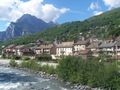
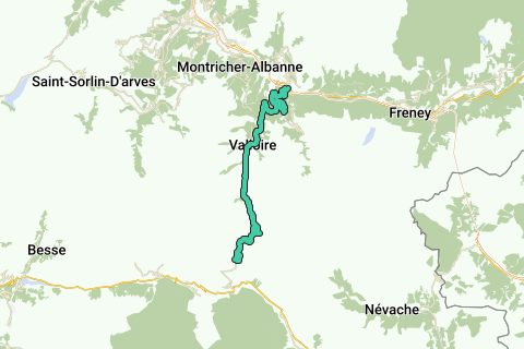
Discover all benefitsClimb to the Col de Galibier from Saint Michel de Maurienne, via Col de Télégraphe. The climb gets you to a height of 2642m over a length of about 35 km. The height difference from the start is 1933m. The average slope is 5.48% with max. slopes of 15%. The col is open from June till October.
See something wrong on this route?Add an issue
Navigate route in...
![]() RouteYou app Open
RouteYou app Open
Don't want to see this ad anymore?
→ Upgrade now
![]()
Please wait, the navigation is being prepared.
You can now navigate. Have fun on the road!
Processing your request has failed. Please try again.
Don't want to see this ad anymore?
→ Upgrade now
![]()
Please wait, your download is being prepared.
Your download is ready. Have fun on the road!
Processing your request has failed. Please try again.
Don't want to see this ad anymore?
→ Upgrade now
![]()
Please wait, your print is being prepared.
Your print is ready to download. Have fun on the road!
Processing your request has failed. Please try again.
<iframe src="https://plugin.routeyou.com/routeviewer/free/?language=en&params.route.id=2005972" width="100%" height="600" frameborder="0" allowfullscreen></iframe>
<p><a class="routeYou_embed" href="https://app.routeyou.com/en-fr/route/view/2005972?utm_source=embed&utm_medium=article&utm_campaign=routeshare&navigation=external" title="Col du Galibier from St.Michel de Mairienne - RouteYou" target="_blank"><img src="https://image.routeyou.com/embed/route/960x670/2005972-en@2x.png" style="width: 100%; height: auto;" alt="Col du Galibier from St.Michel de Mairienne"></a></p>
Additional feedback:
This feature is only available to RouteYou PREMIUM subscribers.
Try 1 month for free and discover the difference! We don't take any payment details, and your trial ends automatically after one month.
© 2006-2026 RouteYou - www.routeyou.com