Datenquelle: Groenehartstocht
During the Bronze Age, there must have been people walking around Nieuwerbrug. The evidence for this is a spearhead from that time, which was found during the excavation of the Put van Broekhoven. This spearhead can now be admired at the National Museum of Antiquities in Leiden.
![]()
Spearhead from the Bronze Age.
collection: National Museum of Antiquities Leiden
Roman Era
The northern border of the Roman Empire ran along the Rhine, which means it went through Nieuwerbrug. Remains of the border road, or Limes, have been found during research.
During the excavation of the Put van Broekhoven, a beautiful rider's helmet was discovered. This can also be admired at the National Museum of Antiquities in Leiden. However, unofficial finds, such as a collection of amphorae, are also known.
Between the two castella (forts) of Woerden and Zwammerdam, watchtowers were located. Various ones have stood in our village.
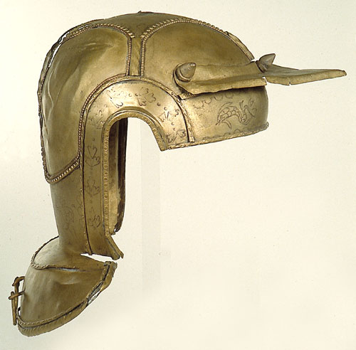
Roman rider's helmet.
collection: National Museum of Antiquities Leiden
Middle Ages
From the 10th century onwards, the clay of Bekenes was mined and from the 11th century, the peat marshes, which were later reclaimed.
A part of this reclaimed land in Nieuwerbrug was donated to the Johanniter order. They manage this from the Hof te Waarder.
The Rhine was of great importance for the transport of people and goods, especially after the digging of both Wierickes around 1365, which established a connection with the Hollandse IJssel. Where the Dubbele Wiericke flows into the Rhine, a settlement may have arisen. Possibly, a bridge was founded then, an old bridge, later replaced by a “new bridge”? There was a chapel, probably built from private initiative, of which the land was managed after demolition by non-clerical, Reformed Chapel Masters.
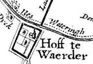
Hof te Waarder on a map from 1670.
collection: RHC Rijnstreek and Lopikerwaard
Eighty Years' War
During the Eighty Years' War, the city of Woerden rebelled against the Spanish King. The Spaniards wanted to besiege Woerden but could not get close because the polders around the city were flooded.
The Spaniards then built a number of fortifications along roads and rivers to prevent the people of Woerden from obtaining food. One of these Spanish fortifications was located in Nieuwerbrug, where the Dubbele Wiericke flows into the Rhine.
Eventually, the Spaniards withdrew. The Nieuwerbrugschans would come in handy 100 years later.
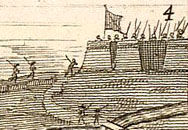
Nieuwerbrugschans in detail from 'The Siege of Woerden.'
collection: Michiel van de Burgt
A village under four municipalities
Nieuwerbrug originated around a bridge over the Rhine, at the corner of the four districts of Bodegraven, Waarder, Barwoutswaarder, and Rietveld. Because the village was far from the four main centers, the village community managed many things themselves. The school from 1610, the bridge, the fire department, and many more. The area in which the community managed these affairs was the Brandschouwerij Nieuwerbrug. In this area, fire was fought, but also prevented by the 'fire checks'.
When the stone bridge was in very poor condition, the people of Nieuwerbrug had to replace or demolish it. They replaced it with a wooden drawbridge. To finance this, they were allowed to collect tolls from 1651. It also came in handy that in 1664 the Jaagpad was constructed.
This brought trade and industry to the village: an inn called 'Het Witte Paard', (later Het Grauwe Paard), artisans, merchants, millers, and bakers.
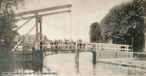
The wooden toll bridge in 1902.
collection: Gijs Boer
In 1672, the Dutch Republic was attacked by France, England, Cologne, and Münster. To stop the French army, the Holland Water Line was flooded. In Nieuwerbrug, the old Spanish fort was renovated. Prince William III himself stayed here and had his army camp at the site of the current Fort Wierickerschans.
Key figures from the war met at the fort and in the camp.
Unfortunately, the Water Line froze, allowing the French to move around Nieuwerbrug. When they could not advance further at Zwammerdam, they retreated. In the process, all buildings in Zwammerdam, Bodegraven, and Nieuwerbrug were burned.
To prevent this from happening again, the current Fort Wierickerschans was built at the Enkele Wiericke. At the Dubbele Wiericke, Fort Nieuwerbrug was erected, with Fort Pain et Vin across the Rhine.
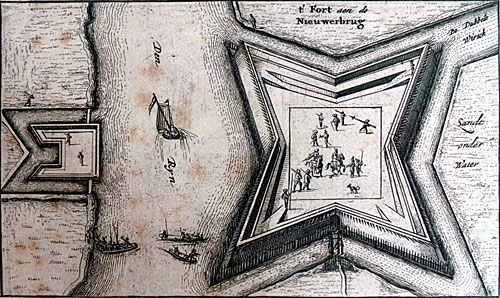
Fort Pain et Vin (left) and Fort Nieuwerbrug (right) along the Old Rhine, the Dubbele Wiericke. 1673
collection: Michiel van de Burgt
Modern Era
Due to the good connection over water, a brick factory, timber merchants, and sawmills settled in and around the village in the 19th century. Transport was not only by water anymore, but also by rail. A train stop on the Leiden-Utrecht line bore the name Waarder but was located on the Molendijk in Nieuwerbrug.
At the railway bridge, a major train accident occurred in 1902. Photos of this were sold as postcards at the time.
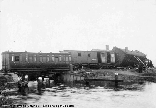
Train accident near Wierickerbrug. 1902
collection: Railway Museum
First World War
During the First World War, English, French, and German soldiers were interned at Fort Wierickerschans.
They stayed in the storage sheds and were guarded by no fewer than 180 men.
At first, a strict regime prevailed, but later the rules loosened. The powder house was used as a church and for recreation. People played football on the grounds, swam in the canal, and two tennis courts were created, where lectures, plays, and musical performances could be attended.
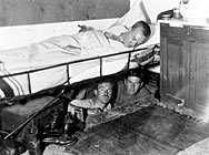
Captured officers in the escape tunnel under Fort Wierickerschans.
New Highlights
To celebrate that our country has been free for a hundred years, the Nieuwerbrug ice club association built the Independence Tower in 1914. This belongs to the villagers and is managed by the Bruggemeesters, the managers of the Toll Bridge.
In 1917, Reformed residents of Nieuwerbrug had the Bridge Church built. The first real church in our village.
For the construction of the A12, sand was taken from the Put van Broekhoven in the 1930s, resulting in a clear (swimming) pond.
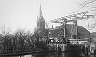
Independence Tower without Bridge Church. collection: RHC Rijnstreek and Lopikerwaard
During the Second World War, the Germans occupied the school and Fort Wierickerschans. The resistance printed pamphlets in the attic of the Fire Department and engaged in shootouts with the SS.
Ships on the Rhine and watchhouses along the railway were shot at or bombed from the air.
Read more >>
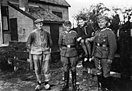
Pier Kool with two German soldiers.
collection: Arie van den Berg Mzn
The “new” village
After 1945, extensive building took place in the village and it gained a real core. Initially, it was mainly for residents of Nieuwerbrug and the inhabitants of Rietveld, Barwoutswaarder, and Waarder. But from the 1970s, people from outside the direct area also moved in. After the municipal reorganization of 1964, almost the entire Brandschouwerij Nieuwerbrug fell under the municipality of Bodegraven. A part ended up with Woerden, now even in a different province. The residents remain active together with their own community center, village newspaper, school, churches, and associations, including those villagers who have found themselves in another province.
Datenquelle: Nieuwerbrug.net
![]() | | Öffentlich | Deutsch • Dänisch • Französisch • Italienisch • Niederländisch • Spanisch
| | Öffentlich | Deutsch • Dänisch • Französisch • Italienisch • Niederländisch • Spanisch

Wählen Sie eine der beliebtesten Aktivitäten unten aus oder verfeinern Sie Ihre Suche.
Entdecken Sie die schönsten und beliebtesten Routen in der Gegend, sorgfältig gebündelt in einer passenden Auswahl.
Datenquelle: Groenehartstocht
Wählen Sie eine der unten aufgeführten beliebtesten Kategorien oder lassen Sie sich von unserer Auswahl inspirieren.
Entdecken Sie die schönsten und beliebtesten Sehenswürdigkeiten der Gegend, sorgfältig gebündelt in einer entsprechenden Auswahl.
Datenquelle: Groenehartstocht
Mit RouteYou kannst du ganz einfach eigene Karten erstellen. Plane deine Route, füge Wegpunkte oder Knotenpunkte hinzu, plane Sehenswürdigkeiten und Einkehrmöglichkeiten ein und teile alles mit Familie und Freunden.
Routenplaner

<iframe src="https://plugin.routeyou.com/poiviewer/free/?language=de&params.poi.id=8197009&params.language=en" width="100%" height="600" frameborder="0" allowfullscreen></iframe>
![]()
Mehr als 11.800.000 Routen
![]()
Mehr als 15.000.000 Benutzer
![]()
Mehr als 4.500.000 Sehenswürdigkeiten
Kerkstraat 108
9050 Gentbrugge,Belgien
© 2006-2026 RouteYou - www.routeyou.com


