871 visites | Pública | Alemany • Francès • Neerlandès
This path is a shortcut of the bike loop that you can view in the TAB 'Routes' of https://www.routeyou.com/user/view/124619/wy-homepage.nl: 'Silver Triangle Zenne Barebeek Dijle' (all routes will be visible at the end of this tab).
This Golden Triangle begins at the same location at Weerdse fish pond (north parking lot) and uses the (opened at the end of 2011) bridge over the Zenne at Zennegat, allowing you to cross from the left banks of the Dijle to the Zenne (see also below for an update on this particular improvement). It offers a very pleasant flat and rural bike loop (mostly car-free) of 40 km, where there is much to experience for the sporty family, providing plenty of variety and surprises – including a petting zoo, discovering two water streams above each other, observing storks, and at various spots the chance for a drink break with play opportunities or a snack. Riding through Mechelen also leads past a park or along low-traffic areas of the Binnendijle.
A geographical peculiarity of this loop is that it passes from the Zenne to the Dijle basin in a special way. The Barebeek arises from a compilation of small ditches between Machelen and Zaventem and is located in the Dijle basin (see http://www.vmm.be/publicaties/ecol_herstel/Barebeek.pdf and http://publicaties.vlaanderen.be/docfolder/168/Computermodellering_Barebeek.pdf). In the vicinity of Vriezenbroek in Weerde, the Barebeek is less than 150 m from a Zenne meander in a flat field. Undoubtedly, this is the closest point between two water streams of the Dijle and Zenne basins upstream from Zennegat. See here if you can't find the POI: https://www.routeyou.com/location/view/47513750/zennebekken-zenne-links-en-dijlebekken-barebeek-rechts-op-slechts-150m-van-elkaar-te-weerde.nl. (Before the construction of the E19, the Barebeek meandered along the Rubenskasteel and then further up to Weerde; now it has been short-circuited on the right side of the highway, but even back then, the Barebeek was further from the Zenne at this spot.) This bike route uses this shortest section of 150 m to traverse the two basins in a looping manner.
TRAJECT with information for this shortcut: The tour starts at the north parking lot of the fish pond Weerde and leads us upstream over the fish pond to the Zenne. We continue to Schumanlaan and turn left without crossing it. This takes us in the opposite direction, and we must be particularly cautious of oncoming cars on the ramps of the E19 who may not notice us. Immediately left twice across the highway. This brings us to the Zenne meanders to the right of the E19. We briefly pass through a small woodland (a bit prickly in summer) and reach the railway track, which we follow to the right. Right at the Zenne, we can go under the railway line and then cross over the only remaining old bridge of the slow path interrupted by the E19 over the Zenne. After 4 km, we arrive at a sharp Zenne meander leading to the E19, over which the new railway bridge Mechelen-Zaventem runs. The Barebeek is located there northeast in the field less than 150 m away.
From there, we follow the Barebeek to its lower course under the Leuvensevaart (after 8.5 km). Initially along the trail 'between Zenne and Barebeek' (= take the Zemstsesteenweg to the right over the Barebeek and slightly further left into the woodland). Further in Hofstade, the Barebeek splits; we follow the northern fork by first turning left over the Barebeek at Tervuursesteenweg and then taking the sharp curve to the right (Balkweg, dead end), which leads to the garden path 'Barebeekwandeling', which we follow. A little further, you can take a dead-end path to the right, which leads along a house to the Barebeek split: you can walk over a small bridge over the northern (or small) Barebeek 50m further to see the split. (See the POIs on site)
This northern division is further pursued (return from the dead end) to the lower course at Leuvensevaart.
There you will see the northern (small) Barebeek from the right rejoining with the southern Barebeek.
It is likely that while digging the canal in 1752, this Barebeek split was rejoined to create only one lower course under the Vaart.
To reach the northern side of the lower course, we must follow the Leuvensevaart upstream for 1.5 km to the next Hofstade bridge and then return along the right bank for 1.5 km.
For the 'creative' runners, there is an alternative to the Hofstade bridge here: On the right bank of the Leuvensevaart (Muizen-Mechelen area), there is an access path to the railway bridge (with railing!). There is no such path on the Hofstade side (Zemst). Too bad... However, you can climb up the slope of the railway line on the Hofstade bridge side in Hofstade (left bank Vaart). The more people use this, the fewer thorns and nettles will block your way. Not a real 'path', but if you climb these few meters, you will have a normal way down on the other side. And at the tracks, you are on the correct side of the bridge, where a narrow footpath next to the tracks leads to the right bank. Zoom in on the railway tracks 27B on the map and click on the POIs there. You’ll also find an NGI map with the marked route to take if you just want to follow the railway tracks 27B between the Zenne and Dijle basins.
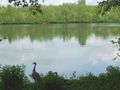
After the lower course, the Barebeek splits again into its original separated beds and continues its own way through the Plankendaal zoo. From the Vaartdijk, you will certainly be able to spot some storks and other animals. The detour is worth it!
After the lower course, we follow the northern small Barebeek again. We cross Leuvensesteenweg, follow the left bank, and go under the Mechelen-Muizen-Hofstade-Weerde railway line and further under the Mechelen-Haacht-Leuven railway line. At the T, turn right to pick up the small Barebeek again. At the end of this path, we already see the confluence of the Barebeek into the Dijle ahead of us. Between this T and the confluence, the two side arms flow back together east of the woodland. We turn right, first cross the northern and then the southern Barebeek. Right behind this second bridge, we take the path to the left bank of the Dijle, which we keep on the left until the confluence of the Barebeek (after 15 km).
We continue to follow the Dijle towards Mechelen and choose the right bank in Muizen, which allows us to cross the Dijle shortcut (with high flow to prevent flooding in the city center) and the Binnendijle (fed from the decommissioned Dijlesluis, with low flow) just before entering Mechelen. This sluice access must be dredged annually (dozens of trucks with excavators - sediments - must be removed; otherwise, the Binnendijle runs dry).
Once on the left bank, we pass under various bridges 'above' the Binnendijle. One of these bridges was even built in different phases over the other, not coincidentally the railway bridge (Is this related to the systematic raising of the railway line Mechelen-Vilvoorde-Brussels?).
In Mechelen, we come across the busy inner ring. Cross this at the nearest traffic lights to the right. This also brings you to the right bank of the Dijle, which we continue to follow along the water mill and the herb garden. After the herb garden, you have two options:
1. Cross the Binnendijle to the left bank and go from the left side over the Dijle bridge to the Dijlepontons (walking is allowed, cycling officially not). At the end of the pontoons, you can easily get back up, after which you continue cycling on the left bank. This is particularly fun.
2. Stay on the right bank and take the second bridge (= pedestrian and bicycle bridge at Vismarkt). This is the suggested bike route.
If you stay on the right bank, you will be enclosed at the junction to the Dijle shortcut.
We continue to follow the left bank of the Dijle to its furthest point at Zennegat and then return at the sluice complex of the canal, where for now you are allowed to cross the canal via the second sluice gate.
Then follow the canal to its furthest point at Zennegat (from the bank, you have a wonderful view!), you can also get a drink there if the café is open.
Then briefly follow the right bank of the Zenne and cross the new fixed Zennegat bridge over the Zenne, so you can keep it on the left bank to Weerde (thirsty people can also drink a bit right next to the Zennegat bridge). From the fixed Zennegat bridge, there are still three bridges over the Zenne to Weerde (Heffen, Leest, Hombeek). You can easily switch to the path at the other bank from Zennegat as long as you take the left bank of the Zenne after the third bridge (before the passage under the railway line at Hombeek).
In Weerde, you can briefly stop by the petting zoo at Gulderij. This is located 100 m from the Zenne meander, which emerges from the right side under the E19 and the new railway line (see the start of the route: This underpass looks in the direction where the Zenne and the Barebeek are less than 150 m apart). The sight there is wonderful: At the same spot, two bridges lie one above the other over the Zenne (E19 over the Zenne and above it the new railway line).
After the petting zoo, we take the first slow path left (Kleine Losweg) along some horse meadows, to then follow the Weerde-Hofstade railway line to the right and go slightly further left down and again turn left, heading back to the starting point.
You can skip the petting zoo and the view of the bridges over the Zenne, which shortens your distance by 600 m.
For the runners: If you do not take the two dead ends in the route (split North and South Barebeek and petting zoo at Gulderij), the running distance effectively amounts to 39 km.
Have fun with this Golden Triangle along the natural watercourses!
{Update November 2011:} At the end of 2011, the first development at Zennegat was successfully completed (fixed bridge over the Zenne). For now, cyclists are allowed to cross over the sluice gate over Leuvensevaart, but a movable bridge will come here. You can thus get from the left bank of the Dijle over Zennegat to the left bank of the Zenne.
To get from the Zenne to the Barebeek near Vriezenbroek in Weerde, this tour must currently proceed via Schumanlaan.
Has vist alguna cosa en aquesta ruta?Afegir un problema
Navega per la ruta a...
![]() Aplicació RouteYou Obriu
Aplicació RouteYou Obriu
Deixar de veure aquest anunci?
→ Millorar ara
![]()
Espereu, s'està preparant la navegació.
Ara pots navegar. Diverteix-te a la carretera!
Processament de la sol·licitud ha fracassat. Si us plau, torneu a intentar.
Deixar de veure aquest anunci?
→ Millorar ara
![]()
Espereu, s'està preparant la teva descàrrega.
La teva descàrrega està llesta. Diverteix-te a la carretera!
Processament de la sol·licitud ha fracassat. Si us plau, torneu a intentar.
Deixar de veure aquest anunci?
→ Millorar ara
![]()
Espereu, s'està preparant la teva impressió.
La teva impressió està llesta per descarregar. Diverteix-te a la carretera!
Processament de la sol·licitud ha fracassat. Si us plau, torneu a intentar.
<iframe src="https://plugin.routeyou.com/routeviewer/free/?language=ca&params.route.id=450481&params.language=en" width="100%" height="600" frameborder="0" allowfullscreen></iframe>
<p><a class="routeYou_embed" href="https://app.routeyou.com/en-be/route/view/450481?utm_source=embed&utm_medium=article&utm_campaign=routeshare&navigation=external" title="Golden Triangle Zenne Barebeek Dijle (40 km) - RouteYou" target="_blank"><img src="https://image.routeyou.com/embed/route/960x670/450481-en@2x.png" style="width: 100%; height: auto;" alt="Golden Triangle Zenne Barebeek Dijle (40 km)"></a></p>
Feedback adicional:
Aquesta funció està disponible únicament per als subscriptors de RouteYou PREMIUM.
Prova-ho gratuïtament durant 1 mes i descobreix la diferència. No demanem dades de pagament i es desactiva automàticament després del període de prova d'un mes.
© 2006-2026 RouteYou - www.routeyou.com