Hiking and cycling tour around the Brussels area. The cycling route sometimes deviates from the walking route: the latter is more beautiful and is preferred.
Marked in both directions. Due to major or minor works, there are sometimes detours that are well signposted. A self-made (i.e. unmarked) small detour leads through the impressive Tournay-Solvay Park rather than around it (km 28.8 - 29.1).
Free ring booklet at Leefmilieu Brussels Tel. 02 775 75 75
Cycling map of the area (with Green Walk) available at bicycle stations and cycling clubs (2 euros); digital https://data.mobility.brussels/mobigis/en
At many points, the route crosses a tram, metro, or train stop that you can reach by bicycle.
Detailed article in the magazine FIETSEN MOET KUNNEN No. 70
(www.fietsenmoetkunnen.be )
Cycling around Brussels? The Gordel is well-known: it runs through the Flemish outer municipalities.
There is also a beautiful circular route through the Brussels area. This hiking and cycling route was designed by the Environmental Protection Service and officially inaugurated in 2008.
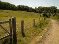
You will pass through many natural areas, often part of the European ecological network "Natura 2000". Cyclists are usually allowed to ride through green spaces. If not, they will be redirected with separate signs. However, it is better to briefly dismount and follow the walking path, which is much more beautiful.
There is a lot of variety. When the route runs through streets, traffic is limited or there are safe bike paths. When a heavily trafficked road is crossed, there are traffic lights.
The route is marked in both directions. The posts stand at a height of 1 or 2 m: so be careful not to overlook them. Since 2023, the route also follows junctions.
Information panels show the entire route, directional signs for nearby parks, monuments, and public transport junctions; special signs provide information about wildlife, plant life, or history.
A map is useful if you get lost. There is a brochure, but the cycling map of Brussels is very good: a street map with all cycling routes and the Green Walk. Routeyou also offers the option to download the gpx file.
Train, tram, and metro lines cross the route. This allows you to easily get there and return to other locations. You can take your bike on the train for a fee, on the metro and the new trams of the MIVB (Brussels transport company) for free outside peak hours. Not on the buses. The MIVB plan can be picked up for free at all metro station counters.
Sint-Agatha-Berchem
If you come by train, Sint Agatha-Berchem station is a good starting point. Follow the exit to Nestor-Martiensstraat on the platform and turn right; then take the second left (Guy Demanetpad) and you are on your way.
By car, you can reach it from the ring road/E40 (Ostend-Brussels). This merges into the Emperor Charles Avenue (R20). On the left is the shopping center "Basilix", on the right a meadow on a slope. There are parking options on both sides, especially in the shopping center.
But you can also start this tour elsewhere. There are train stations in Boitsfort, Uccle-Kalevoet, Schaerbeek, Evere, Bordet, Jette; metro stations: Herrmann-Debroux, Erasmus, Stuyvenbergh, Vandervelde.
By car via the E40 (Leuven-Brussels) exit 19 Evere-Woluwe, ring exit 18 Uccle and 1 km further P+R, A12 (Antwerp-Brussels) to the endpoint Laken.
To Heysel
Soon you will enter the King Baudouin Park. It is elongated and follows the valley of the Molenbeek. There are also numerous water areas. The area was originally reserved for the Sint Niklaas - Dendermonde - Brussels motorway, which was never realized.
On the other side of the Bosstraat (cobblestone street) lies the Laarbeekwood. There you will find the Norman lodge: a great place to get a drink.
At the end of the Boudewijnpark, turn right, and you will find the back of the Jette station. Here you have a connection to Brussels on one side, Aalst and Dendermonde on the other.
Further on, under the Bockstaellaan runs the metro line 1A. The Stuyvenbergh stop is nearby.
Follow a series of parks: Sobiesky Park, Colonial Garden (on foot), Park of Laken.
To the right is the royal area and the Stuyvenbergh castle.
We leave the Atomium and Heysel on our left.
We pass the American theater, which was a VRT studio until 2012. The path used to go through a series of tunnels. These were created during the Expo 1958 to guide the public from the tram stop to the World Expo. These tunnels run under the roundabout that marks the beginning of the A12 and even over the platforms of today's tram stop "De Wand".
The route passes by the Chinese House and the Japanese Tower: impressive buildings that we owe to King Leopold II. Be sure to take a close look at them; they are temporarily not open for internal visits (https://www.regiedergebouwen.be/en/projects/japanese-towers). The stained glass windows in the Japanese Tower provide a very different image than those in our cathedrals. To fully admire them, a little sun is desirable.
To the Zenne and the Woluwe
Now follows a long descent into the valley of the Zenne, over the Van-Praet bridge from the Brussels Canal to Willebroek. Here you can also see the Zenne coming briefly to the surface.
After a bridge over a rail bundle, you can turn left to Schaerbeek station.
The bicycle route leads to the “Moeraske,” a nature reserve through which you ride, and then to the Park of the Good Shepherd.
At the intersection of the Haachtsesteenweg, the Bordet station is on the left after 300 m.
The Green Walk now passes by the cemetery of the City of Brussels. It is 150 hectares large and very beautifully landscaped. Take a look at the magnificent coffins of dignitaries; harder to find are the simple crosses of the Poverello homeless.
Through a more urban environment, the route leads into the valley of the Woluwe: this is a brook that flows into the Zenne. Cyclists will be rerouted along the chapel of Lenneke Mare and the windmill Hof ter Mussen. The entire area back there is occupied by UCL with its stylish metro station "Alma". Closer is the Vandervelde metro station. (Line 1B)
On foot, you can follow the Woluwe, nestled in a green environment, with its Lindekemaalmolen.
At the corner of Vanderveldelaan is a quiet café: the Brasserie Kwak.
Through the Malou Park, which looks like a forest, you come to the old railway line Etterbeek-Tervuren, which is now a walking and cycling path.
An impressive bridge has been laid over the Tervurenlaan, from which you can see the tram museum.
The railway line runs through the Park of Woluwe with its ponds. If you follow the line, you will reach the metro station Beaulieu and further on to the university campus of VUB/ULB and to Etterbeek station.
The Green Walk follows the Woluwe, does not pass far from Hertoginnedal Castle, and runs along the H.Debroux metro station.
If you follow the cycle path in H.Debrouxlaan one kilometer east, you will reach the “Red Monastery”.
After the Sony and Ten-Reuken Park, you will enter the Zoniën Forest.
The Zoniën Forest
We leave the valley of the Woluwe with a short but vigorous ascent and are immediately in the forest. The cemetery of Boitsfort also leans against it; take a moment to enjoy the view of the surroundings.
Just behind the pond of Boitsfort, a detour to Tournay-Solvay Castle is worthwhile.
After a vigorous climb in Vuurkruisenweg, where the route turns left to Twee Bergenlaan, you will see a gate on the right. Behind it lies the vegetable garden of the castle, which is now used by the residents. From there, you walk through an orchard; in the middle of the grounds, high on a hill, stands a dilapidated but impressive castle. Further still is an exit to Dennebosstraat, which leads to the Boitsfort station.
The Twee Bergenlaan – a big word for a narrow street – runs under the railway line and gently rises to Lorreinendreef. There stands a giant sequoia with a trunk circumference of 6.3 m!
Uccle
This municipality is particularly green and therefore desirable. A house here costs three times as much as a villa in Flanders.
Through the Verrewinkel forest, the nature reserve Kriekenput and Kinsendaal, you pass under an imposing railway viaduct. To the right is the Ukkel-Kalevoet station.
Hourly you can take a train back to the starting point, with a transfer at Brussels-North.
Under this viaduct, the path continues, through the green Keyenbempt to Vorst.
At Stallestraat, you will reach the tram stop 'Stalle P' (P+R). With tram 4, you can return to the North Station.
Vorst – Anderlecht – Molenbeek - Berchem
The stretch in Vorst, about 6 km, has little to offer: a lot of outdated industry, a (temporary?) detour along a heavily trafficked road.
If you go under a railway line, you are at Vorst-Zuid station and can return to the starting point, with a transfer in Brussels.
From Anderlecht, the surroundings become interesting again. The Bollinckxstraat briefly shows us the Zenne before it dives underground and only comes back to the surface after Brussels.
You cross the lock gate of the Brussels-Charleroi canal and follow the shortcut for a few kilometers. Well located by the water is the Brasserie Luciano.
Then the Vogelzangbeek is followed. When you leave this, you come to the terminal station of metro line 1B: to the Erasmus station. The university hospital of ULB is also located here.
At the ponds of Neerpede, you will see the Luizenmolen, the second windmill on the route.
The surroundings connect to the Pajottenland: rural, with some hills.
After Peterbos, you will briefly enter Molenbeek, through the Scheutbos.
Finally, Berchem follows with the Wilderbos, Kattenbroek, Hunderenveld, and Zavelenberg.
This beautiful "mountain" is a meadow; the grazing cows look at the shopping center Basilix, from where we started.
Overview
- Distance: 62 km
- Start: Sint Agatha Berchem
- Shortening: various options
- Public Transport: www.belgiantrain.be (train); www.mivb.be (metro & tram)
- Relief: quite flat, limited slopes
- Safety: be careful due to intersections with roads
- Special feature: nature and city, with a lot of variety
- Highlights: Atomium, Brupark, Oceade, Mini-Europe, Chinese Pavilion, Japanese Tower, Hertoginnedal Castle, Abbey of the Red Monastery, Zoniën Forest, …
- Bicycle rental: at various stations (www.cyclo.org/en/locations/bike-station-north)
- Leaflet, information: Leefmilieu Brussels www.groene-wandeling.be Tel. 02 775 75 75
- Cycling map Brussels: Cycling association Alte Kornmarkt 63 Tel. 02 502 68 51 brussel@fietsersbond.be
Mobile Brussels 0800 94 001 or 0800 85 775
- Detailed map (downloadable for GPS): www.routeyou.com/route/view/61596/fietsroute-de-groene-wandeling.nl
See something wrong on this route?Add an issue
Navigate route in...
![]() RouteYou app Open
RouteYou app Open
Don't want to see this ad anymore?
→ Upgrade now
![]()
Please wait, the navigation is being prepared.
You can now navigate. Have fun on the road!
Processing your request has failed. Please try again.
Don't want to see this ad anymore?
→ Upgrade now
![]()
Please wait, your download is being prepared.
Your download is ready. Have fun on the road!
Processing your request has failed. Please try again.
Don't want to see this ad anymore?
→ Upgrade now
![]()
Please wait, your print is being prepared.
Your print is ready to download. Have fun on the road!
Processing your request has failed. Please try again.
<iframe src="https://plugin.routeyou.com/routeviewer/free/?language=en&params.route.id=61596" width="100%" height="600" frameborder="0" allowfullscreen></iframe>
<p><a class="routeYou_embed" href="https://app.routeyou.com/en-be/route/view/61596?utm_source=embed&utm_medium=article&utm_campaign=routeshare&navigation=external" title="The Green Way - RouteYou" target="_blank"><img src="https://image.routeyou.com/embed/route/960x670/61596-en@2x.png" style="width: 100%; height: auto;" alt="The Green Way"></a></p>
Additional feedback:
This feature is only available to RouteYou PREMIUM subscribers.
Try 1 month for free and discover the difference! We don't take any payment details, and your trial ends automatically after one month.
© 2006-2026 RouteYou - www.routeyou.com