During our queens' ride, we seek out the route of Les Trois Ballons, but limit ourselves to about half of the kilometers and half of the climbs. More than 2500 meters of elevation gain is enough for us. It should remain a bit enjoyable. We do this not only by seeking out the beautiful cols but also by crossing the area of "Les mille Etangs." A less known, but very beautiful cycling area that is actually no longer in the Vosges, but just over the border in Haute-Saône.
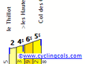
We start towards Le Thillot to immediately warm up our legs with a first small climb. The summit of the Col des Croix is at 678 meters after 4 kilometers at an average of 4.5%. However, the slope gradually rises from 2% to 4.5% and even 6.5% in kilometer 3 over the first three kilometers. The last kilometer eases back a bit to 5.5%, but upon reaching the summit, we take a sharp right onto the D57 and climb another 2 kilometers at around 3% to 760 meters.
We now ride for kilometers on the border of Les Vosges and La Haute-Saône, seeing the first ponds appear to our left and right. We continue following the D57 until we reach a T-junction with the D6 at kilometer 19 in the descent. There we turn left and descend further until we reach the village of Faucogney-et-la-Mer after 31 kilometers.
In Faucogney-et-la-Mer, we turn left towards the center and then right onto the D236. This takes us, once outside the center, along a very beautiful winding road through the forests and past the many ponds to Servance. However, the road begins with a steep climb from 360 to 500 meters, then continues to rise gradually up to 550 meters and finally descends into Servance after 12 kilometers.
Just before we exit the village center of Servance, heading towards Plancher-les-Mines, we take a sharp left towards Miellin for the ascent of the Col de Chevrères, consistently included in the route of Les Trois Ballons. We start with a short climb, but further on, we lose that elevation again, and the road gradually rises for another 5 kilometers at 2 to 3%. Once past Le Miellin, the col really begins and becomes quite challenging. From Servance, the col is 9.5 kilometers long with a height difference of 515 meters to the summit at 920 meters. An average of 5.5%, but after the long approach, these last 4 kilometers are particularly difficult with nearly continuous gradients of over 10%. With three kilometers left to climb, we even face one kilometer averaging 14.8% and maximums approaching 20%! Fortunately, it levels off a bit afterward, and the last kilometer is somewhat more manageable.
After the summit, we descend to the junction with D97, where we take a left to turn left again a few kilometers later towards Plancher-les-Mines. From here, we have actually already started the ascent of the Col de Servance, but another two kilometers further, we leave it aside for a moment to go straight and tackle the highlight of the day: the famous and infamous Planche des Belles Filles. There’s little chance you’ll meet those beautiful girls here. There’s much more chance that it will be a tough grind with those belles filles!
With an average of 8.5% and more than half of the kilometers above 10%, this will be a heavy burden for most. The (real) summit is at 1035 meters, and after 5.6 kilometers, we will have covered more than 450 meters of elevation gain! At the junction at the foot of the Planche des Belles Filles, the road steeply winds upward, and it becomes immediately clear that the first kilometers will be particularly tough. Below, it is also indicated on the sign: maximum slope 22%!
But don’t let that discourage you; the Planche des Belles Filles is only 5.5 kilometers long, and the first kilometers are the hardest. From kilometer four, the average drops to 9.8%, and in the last kilometer down to 5.8%. To truly reach the top, however, you still have to pedal a bit further and turn sharply right to go steeply up for another 500 meters. At the summit, there’s a sign with Froome’s record time in the 2012 Tour. He did it in just under 16 minutes and 11 seconds! Incredible!
At the top, you can eat or drink something at the Refuge de la haute Planche, if it’s open, of course. Afterwards, as a road cyclist, you can only return the same way. We carefully descend and turn right on the D16 to immediately resume the climb of the Col de Servance. Another 9 kilometers to the summit at a respectably 1158 meters, 550 meters higher than the foot of the Planche des Belles Filles. An average of 6%, but again the last kilometers are the toughest, with 11% and 9% between 5 and 3 kilometers from the top. The last two kilometers see the gradient first drop to 7% and finally to 5.8%.
We descend to the top of the Col des Croix and ride right down towards Le Thillot. Just 4 kilometers to Le Ménil, and our queen's ride is already coming to an end!
Iets opgevallen op deze route?Probleem toevoegen
Navigeer de route met...
![]() RouteYou app Open
RouteYou app Open
Deze advertentie niet meer zien?
→ Upgrade nu
![]()
Even geduld, de navigatie wordt voorbereid.
Je kan nu navigeren. Veel plezier onderweg!
Het verwerken van de aanvraag is mislukt. Gelieve het opnieuw te proberen.
Deze advertentie niet meer zien?
→ Upgrade nu
![]()
Even geduld, je download wordt voorbereid.
Je download is klaar. Veel plezier onderweg!
Het verwerken van de aanvraag is mislukt. Gelieve het opnieuw te proberen.
Deze advertentie niet meer zien?
→ Upgrade nu
![]()
Even geduld, je afdruk wordt voorbereid.
Je afdruk is klaar om te downloaden. Veel plezier onderweg!
Het verwerken van de aanvraag is mislukt. Gelieve het opnieuw te proberen.
<iframe src="https://plugin.routeyou.com/routeviewer/free/?language=nl&params.route.id=3414509&params.language=en" width="100%" height="600" frameborder="0" allowfullscreen></iframe>
<p><a class="routeYou_embed" href="https://app.routeyou.com/en-fr/route/view/3414509?utm_source=embed&utm_medium=article&utm_campaign=routeshare&navigation=external" title="Planche des Belles Filles, Col de Chevrères and Ballon de Servance - RouteYou" target="_blank"><img src="https://image.routeyou.com/embed/route/960x670/3414509-en@2x.png" style="width: 100%; height: auto;" alt="Planche des Belles Filles, Col de Chevrères and Ballon de Servance"></a></p>
Bijkomende feedback:
Deze functionaliteit is exclusief beschikbaar voor RouteYou PREMIUM-abonnees.
Probeer nu 1 maand gratis en ontdek het verschil! We vragen geen betaalgegevens en het stopt automatisch na je proefperiode van een maand.
© 2006-2026 RouteYou - www.routeyou.com